Făcăeni geodata
Făcăeni (Ialomiţa) is a seat of a second-order administrative division; located in Romania in Europe/Bucharest (GMT+3) time zone. With population of 5,893 people, there are 562 cities with bigger population in this country. Compared to other cities in Romania, 83.8% of cities are located further ↑North; 95.4% of cities are located further ←West and 99.3% of cities have higher elevation than Făcăeni. Note1


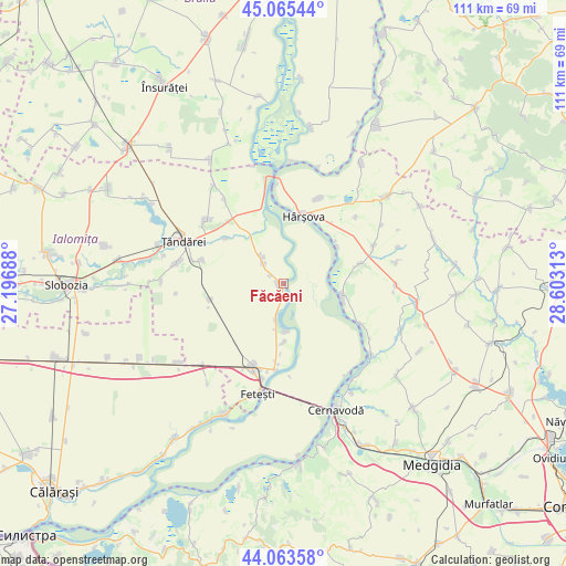
Făcăeni GPS coordinates[2]
44° 34' 0.012" North, 27° 54' 0" East
| Map corner | latitude | longitude |
|---|---|---|
| Upper-left | 45.06544°, | 27.19688° |
| Center: | 44.56667°, | 27.9° |
| Lower-right: | 44.06358°, | 28.60313° |
| Map W x H: | 111.4×111.4 km | = 69.2×69.2mi |
| max Lat: | 48.23793° ⇑83.8% North |
| Făcăeni: | 44.56667° |
| min Lat: | ⇓16.2% South 43.65638° |
| min Long | Făcăeni | max Long |
| 20.31667° | 27.9° | 29.65403° |
| W 95.4%⇐ | ⇒4.6% E |
Elevation
Elevation of Făcăeni is 9 m = 30 ft, and this is 245.9 m = 807 ft below average elevation for this country.
| Max E: |
1278 m = 4193 ft | 99.3% |
| Avg. | 254.9 m = 836 ft | |
| Făcăeni | 9 m = 30 ft | |
Min E: |
-2 m = -7 ft | 0.7% |
See also: Romania elevation on elevation.city.
Geographical zone
Făcăeni is located in North temperate zone (between Tropic of Cancer and the Arctic Circle). Distance of this Northern Tropic circle is 2349.4 km =1459.8 mi to South.| Distance of | km | miles | from Făcăeni |
|---|---|---|---|
| North Pole | 5051.7 | 3139 | to North |
| Arctic Circle | 2445.8 | 1519.7 | to North |
| Tropic Cancer | 2349.4 | 1459.8 | to South |
| Equator | 4955.3 | 3079.1 | to South |


Nearby cities:
15 places around Făcăeni: (largest is in red/bold)
• Borduşani
9.3 km =5.8 mi,  180°
180°
• Cegani
11.6 km =7.2 mi, 179°
• Ciobanu
18.1 km =11.2 mi,  22°
22°
• Fetești-Gară
17.4 km =10.8 mi,  199°
199°
• Ghindăreşti
14 km =8.7 mi,  48°
48°
• Horia
18.7 km =11.6 mi,  66°
66°
• Hârşova
13.8 km =8.6 mi, 16°
• Lăcusteni
18.3 km =11.4 mi,  284°
284°
• Mihail Kogălniceanu
18.5 km =11.5 mi,  314°
314°
• Movila
16 km =9.9 mi,  263°
263°
• Platonești
16.7 km =10.4 mi,  285°
285°
• Progresu
2.9 km =1.8 mi,  300°
300°
• Stelnica
16.7 km =10.4 mi, 184°
• Topalu
11.8 km =7.3 mi,  102°
102°
• Vlădeni
5.7 km =3.5 mi,  346°
346°
Sources, notices
• [Note1] Compared only with cities in Romania existing in our database
• [Src1] Map data: © OpenStreetMap contributors (CC-BY-SA)
• [Src2] Other city data from geonames.org with taken over terms of usage.
• [Src3] Geographical zone / Annual Mean Temperature by Robert A. Rohde @ Wikipedia
