Bolătău geodata
Bolătău (Bacău) is a populated place; located in Romania in Europe/Bucharest (GMT+3) time zone. With population of 1,018 people, there are 4232 cities with bigger population in this country. Compared to other cities in Romania, 70.2% of cities are located further ↓South; 70.9% of cities are located further ←West and 96.5% of cities have lower elevation than Bolătău. Note1


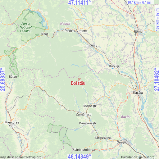
Bolătău GPS coordinates[2]
46° 38' 0.42" North, 26° 24' 5.364" East
| Map corner | latitude | longitude |
|---|---|---|
| Upper-left | 47.11411°, | 25.69837° |
| Center: | 46.63345°, | 26.40149° |
| Lower-right: | 46.14849°, | 27.10462° |
| Map W x H: | 107.4×107.4 km | = 66.7×66.7mi |
| max Lat: | 48.23793° ⇑29.8% North |
| Bolătău: | 46.63345° |
| min Lat: | ⇓70.2% South 43.65638° |
| min Long | Bolătău | max Long |
| 20.31667° | 26.40149° | 29.65403° |
| W 70.9%⇐ | ⇒29.1% E |
Elevation
Elevation of Bolătău is 691 m = 2267 ft, and this is 436.1 m = 1431 ft above average elevation for this country.
| Max E: |
1278 m = 4193 ft | 3.5% |
| Bolătău | 691 m 2267 ft | |
| Avg. | 254.9 m = 836 ft | |
Min E: |
-2 m = -7 ft | 96.5% |
See also: Romania elevation on elevation.city.
Geographical zone
Bolătău is located in North temperate zone (between Tropic of Cancer and the Arctic Circle). Distance of this North polar circle is 2216 km =1377 mi to North.| Distance of | km | miles | from Bolătău |
|---|---|---|---|
| North Pole | 4821.9 | 2996.2 | to North |
| Arctic Circle | 2216 | 1377 | to North |
| Tropic Cancer | 2579.2 | 1602.6 | to South |
| Equator | 5185.2 | 3221.9 | to South |


Nearby cities:
15 places around Bolătău: (largest is in red/bold)
• Balcani
11.3 km =7 mi,  90°
90°
• Borleşti
16.1 km =10 mi,  22°
22°
• Băhnășeni
15.4 km =9.6 mi,  116°
116°
• Băsăști
15.3 km =9.5 mi, 93°
• Cucuieți
10.9 km =6.8 mi, 116°
• Frumoasa
11.2 km =7 mi,  72°
72°
• Ludași
13.7 km =8.5 mi,  96°
96°
• Pârjol
16.2 km =10.1 mi,  110°
110°
• Păltiniș
10.6 km =6.6 mi,  198°
198°
• Schitu Frumoasa
6.6 km =4.1 mi, 88°
• Solonţ
12.8 km =8 mi,  136°
136°
• Stănești
15.6 km =9.7 mi, 139°
• Sărata
13.7 km =8.5 mi, 122°
• Tazlău
10.5 km =6.5 mi,  28°
28°
• Zemeş
5.7 km =3.5 mi,  168°
168°
Sources, notices
• [Note1] Compared only with cities in Romania existing in our database
• [Src1] Map data: © OpenStreetMap contributors (CC-BY-SA)
• [Src2] Other city data from geonames.org with taken over terms of usage.
• [Src3] Geographical zone / Annual Mean Temperature by Robert A. Rohde @ Wikipedia
