Bogaţi geodata
Bogaţi (Arges) is a seat of a second-order administrative division; located in Romania in Europe/Bucharest (GMT+3) time zone. With population of 4,936 people, there are 811 cities with bigger population in this country. Compared to other cities in Romania, 74.4% of cities are located further ↑North; 51% of cities are located further →East and 64.5% of cities have lower elevation than Bogaţi. Note1


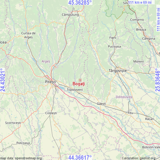
Bogaţi GPS coordinates[2]
44° 52' 0.012" North, 25° 7' 59.988" East
| Map corner | latitude | longitude |
|---|---|---|
| Upper-left | 45.36285°, | 24.43021° |
| Center: | 44.86667°, | 25.13333° |
| Lower-right: | 44.36617°, | 25.83646° |
| Map W x H: | 110.8×110.8 km | = 68.8×68.8mi |
| max Lat: | 48.23793° ⇑74.4% North |
| Bogaţi: | 44.86667° |
| min Lat: | ⇓25.6% South 43.65638° |
| min Long | Bogaţi | max Long |
| 20.31667° | 25.13333° | 29.65403° |
| W 49%⇐ | ⇒51% E |
Elevation
Elevation of Bogaţi is 287 m = 942 ft, and this is 32.1 m = 105 ft above average elevation for this country.
| Max E: |
1278 m = 4193 ft | 35.5% |
| Bogaţi | 287 m 942 ft | |
| Avg. | 254.9 m = 836 ft | |
Min E: |
-2 m = -7 ft | 64.5% |
See also: Romania elevation on elevation.city.
Geographical zone
Bogaţi is located in North temperate zone (between Tropic of Cancer and the Arctic Circle). Distance of this Northern Tropic circle is 2382.8 km =1480.6 mi to South.| Distance of | km | miles | from Bogaţi |
|---|---|---|---|
| North Pole | 5018.4 | 3118.3 | to North |
| Arctic Circle | 2412.5 | 1499.1 | to North |
| Tropic Cancer | 2382.8 | 1480.6 | to South |
| Equator | 4988.7 | 3099.8 | to South |


Nearby cities:
15 places around Bogaţi: (largest is in red/bold)
• Beleţi
5.4 km =3.4 mi,  313°
313°
• Cârstieni
8.3 km =5.2 mi,  282°
282°
• Furești
7.7 km =4.8 mi,  345°
345°
• Glâmbocelu
3 km =1.9 mi,  170°
170°
• Gorganu
8 km =5 mi,  250°
250°
• Ludeşti
7.9 km =4.9 mi,  90°
90°
• Paraschivești
3.7 km =2.3 mi,  294°
294°
• Pitoi
4.4 km =2.7 mi,  295°
295°
• Priboieni
4.4 km =2.7 mi, 295°
• Schitu Scoicești
5.8 km =3.6 mi, 166°
• Suseni
3.9 km =2.4 mi,  12°
12°
• Telești
8 km =5 mi,  69°
69°
• Topoloveni
6.8 km =4.2 mi,  215°
215°
• Urlucea
8 km =5 mi,  270°
270°
• Valea Popii
3.7 km =2.3 mi, 271°
Sources, notices
• [Note1] Compared only with cities in Romania existing in our database
• [Src1] Map data: © OpenStreetMap contributors (CC-BY-SA)
• [Src2] Other city data from geonames.org with taken over terms of usage.
• [Src3] Geographical zone / Annual Mean Temperature by Robert A. Rohde @ Wikipedia
