Blejoi geodata
Blejoi (Prahova) is a seat of a second-order administrative division; located in Romania in Europe/Bucharest (GMT+3) time zone. With population of 7,646 people, there are 343 cities with bigger population in this country. Compared to other cities in Romania, 69.8% of cities are located further ↑North; 63.2% of cities are located further ←West and 56.1% of cities have higher elevation than Blejoi. Note1


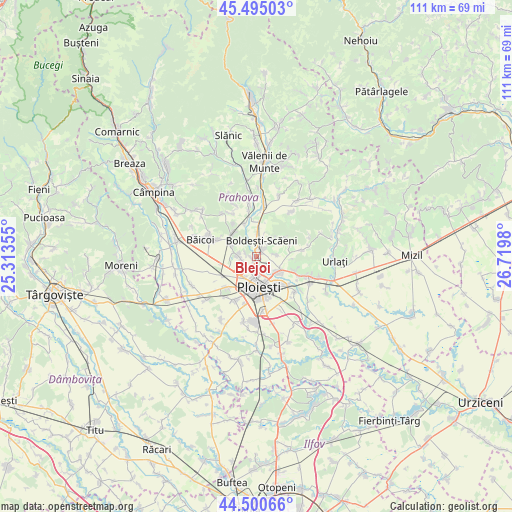
Blejoi GPS coordinates[2]
45° 0' 0" North, 26° 1' 0.012" East
| Map corner | latitude | longitude |
|---|---|---|
| Upper-left | 45.49503°, | 25.31355° |
| Center: | 45°, | 26.01667° |
| Lower-right: | 44.50066°, | 26.7198° |
| Map W x H: | 110.6×110.6 km | = 68.7×68.7mi |
| max Lat: | 48.23793° ⇑69.8% North |
| Blejoi: | 45° |
| min Lat: | ⇓30.2% South 43.65638° |
| min Long | Blejoi | max Long |
| 20.31667° | 26.01667° | 29.65403° |
| W 63.2%⇐ | ⇒36.8% E |
Elevation
Elevation of Blejoi is 182 m = 597 ft, and this is 72.9 m = 239 ft below average elevation for this country.
| Max E: |
1278 m = 4193 ft | 56.1% |
| Avg. | 254.9 m = 836 ft | |
| Blejoi | 182 m = 597 ft | |
Min E: |
-2 m = -7 ft | 43.9% |
See also: Romania elevation on elevation.city.
Geographical zone
Blejoi is located in North temperate zone (between Tropic of Cancer and the Arctic Circle). Distance of this Northern Tropic circle is 2397.6 km =1489.8 mi to South.| Distance of | km | miles | from Blejoi |
|---|---|---|---|
| North Pole | 5003.5 | 3109 | to North |
| Arctic Circle | 2397.6 | 1489.8 | to North |
| Tropic Cancer | 2397.6 | 1489.8 | to South |
| Equator | 5003.5 | 3109 | to South |


Nearby cities:
15 places around Blejoi: (largest is in red/bold)
• Boldeşti-Scăeni
3.9 km =2.4 mi,  19°
19°
• Bucov
6.4 km =4 mi,  125°
125°
• Chițorani
8.5 km =5.3 mi,  109°
109°
• Cocoșești
2.7 km =1.7 mi,  287°
287°
• Găgeni
6.1 km =3.8 mi, 293°
• Lipăneşti
5.6 km =3.5 mi,  0°
0°
• Pleașa
4.4 km =2.7 mi,  81°
81°
• Ploieşti
5.6 km =3.5 mi,  180°
180°
• Ploieștiori
2.1 km =1.3 mi, 177°
• Plopeni
7.5 km =4.7 mi,  317°
317°
• Plopeni
7.8 km =4.8 mi,  339°
339°
• Păuleşti
2.6 km =1.6 mi,  270°
270°
• Seciu
5.2 km =3.2 mi,  46°
46°
• Zamfira
7.6 km =4.7 mi,  355°
355°
• Șipotu
4.5 km =2.8 mi, 0°
Sources, notices
• [Note1] Compared only with cities in Romania existing in our database
• [Src1] Map data: © OpenStreetMap contributors (CC-BY-SA)
• [Src2] Other city data from geonames.org with taken over terms of usage.
• [Src3] Geographical zone / Annual Mean Temperature by Robert A. Rohde @ Wikipedia
