Blăjel geodata
Blăjel (Sibiu) is a seat of a second-order administrative division; located in Romania in Europe/Bucharest (GMT+3) time zone. With population of 2,419 people, there are 2227 cities with bigger population in this country. Compared to other cities in Romania, 59.9% of cities are located further ↓South; 63.5% of cities are located further →East and 67.6% of cities have lower elevation than Blăjel. Note1


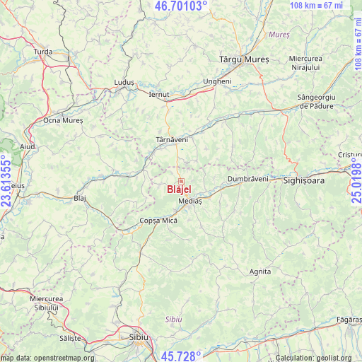
Blăjel GPS coordinates[2]
46° 13' 0.012" North, 24° 19' 0.012" East
| Map corner | latitude | longitude |
|---|---|---|
| Upper-left | 46.70103°, | 23.61355° |
| Center: | 46.21667°, | 24.31667° |
| Lower-right: | 45.728°, | 25.0198° |
| Map W x H: | 108.2×108.2 km | = 67.2×67.2mi |
| max Lat: | 48.23793° ⇑40.1% North |
| Blăjel: | 46.21667° |
| min Lat: | ⇓59.9% South 43.65638° |
| min Long | Blăjel | max Long |
| 20.31667° | 24.31667° | 29.65403° |
| W 36.5%⇐ | ⇒63.5% E |
Elevation
Elevation of Blăjel is 305 m = 1001 ft, and this is 50.1 m = 164 ft above average elevation for this country.
| Max E: |
1278 m = 4193 ft | 32.4% |
| Blăjel | 305 m 1001 ft | |
| Avg. | 254.9 m = 836 ft | |
Min E: |
-2 m = -7 ft | 67.6% |
See also: Romania elevation on elevation.city.
Geographical zone
Blăjel is located in North temperate zone (between Tropic of Cancer and the Arctic Circle). Distance of this North polar circle is 2262.4 km =1405.8 mi to North.| Distance of | km | miles | from Blăjel |
|---|---|---|---|
| North Pole | 4868.2 | 3025 | to North |
| Arctic Circle | 2262.4 | 1405.8 | to North |
| Tropic Cancer | 2532.9 | 1573.9 | to South |
| Equator | 5138.8 | 3193.1 | to South |


Nearby cities:
15 places around Blăjel: (largest is in red/bold)
• Adămuş
11.3 km =7 mi,  325°
325°
• Bazna
3.2 km =2 mi,  234°
234°
• Boian
7 km =4.3 mi,  256°
256°
• Brateiu
9.5 km =5.9 mi,  125°
125°
• Buzd
11.6 km =7.2 mi,  139°
139°
• Băgaciu
6.8 km =4.2 mi,  34°
34°
• Colonia Târnava
9.6 km =6 mi,  195°
195°
• Curciu
7.6 km =4.7 mi,  66°
66°
• Deleni
5.5 km =3.4 mi,  19°
19°
• Dârlos
7.4 km =4.6 mi,  120°
120°
• Mediaş
6.1 km =3.8 mi,  155°
155°
• Păucea
3.2 km =2 mi,  86°
86°
• Târnava
8.8 km =5.5 mi,  193°
193°
• Velț
3.7 km =2.3 mi,  312°
312°
• Șmig
9.9 km =6.2 mi,  84°
84°
Sources, notices
• [Note1] Compared only with cities in Romania existing in our database
• [Src1] Map data: © OpenStreetMap contributors (CC-BY-SA)
• [Src2] Other city data from geonames.org with taken over terms of usage.
• [Src3] Geographical zone / Annual Mean Temperature by Robert A. Rohde @ Wikipedia
