Bârnova geodata
Bârnova (Iaşi) is a seat of a second-order administrative division; located in Romania in Europe/Bucharest (GMT+3) time zone. With population of 3,925 people, there are 1199 cities with bigger population in this country. Compared to other cities in Romania, 80.6% of cities are located further ↓South; 92.3% of cities are located further ←West and 63.2% of cities have higher elevation than Bârnova. Note1


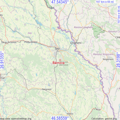
Bârnova GPS coordinates[2]
47° 4' 0.012" North, 27° 37' 0.012" East
| Map corner | latitude | longitude |
|---|---|---|
| Upper-left | 47.54345°, | 26.91355° |
| Center: | 47.06667°, | 27.61667° |
| Lower-right: | 46.58559°, | 28.3198° |
| Map W x H: | 106.5×106.5 km | = 66.2×66.2mi |
| max Lat: | 48.23793° ⇑19.4% North |
| Bârnova: | 47.06667° |
| min Lat: | ⇓80.6% South 43.65638° |
| min Long | Bârnova | max Long |
| 20.31667° | 27.61667° | 29.65403° |
| W 92.3%⇐ | ⇒7.7% E |
Elevation
Elevation of Bârnova is 154 m = 505 ft, and this is 100.9 m = 331 ft below average elevation for this country.
| Max E: |
1278 m = 4193 ft | 63.2% |
| Avg. | 254.9 m = 836 ft | |
| Bârnova | 154 m = 505 ft | |
Min E: |
-2 m = -7 ft | 36.8% |
See also: Romania elevation on elevation.city.
Geographical zone
Bârnova is located in North temperate zone (between Tropic of Cancer and the Arctic Circle). Distance of this North polar circle is 2167.9 km =1347.1 mi to North.| Distance of | km | miles | from Bârnova |
|---|---|---|---|
| North Pole | 4773.7 | 2966.2 | to North |
| Arctic Circle | 2167.9 | 1347.1 | to North |
| Tropic Cancer | 2627.4 | 1632.6 | to South |
| Equator | 5233.3 | 3251.8 | to South |


Nearby cities:
15 places around Bârnova: (largest is in red/bold)
• Chicerea
10.8 km =6.7 mi,  66°
66°
• Ciurbești
7 km =4.3 mi,  298°
298°
• Ciurea
4.2 km =2.6 mi,  243°
243°
• Dancu
10.4 km =6.5 mi,  21°
21°
• Dumbrava
5 km =3.1 mi,  281°
281°
• Goruni
8.8 km =5.5 mi,  61°
61°
• Holboca
11.2 km =7 mi,  34°
34°
• Horpaz
6.9 km =4.3 mi,  311°
311°
• Lunca Cetățuii
5.2 km =3.2 mi, 309°
• Mogoşeşti
7.3 km =4.5 mi, 239°
• Picioru Lupului
4.3 km =2.7 mi,  222°
222°
• Poieni
6.6 km =4.1 mi,  106°
106°
• Păun
5.1 km =3.2 mi,  42°
42°
• Slobozia
5.4 km =3.4 mi,  181°
181°
• Tomeşti
7.5 km =4.7 mi, 42°
Sources, notices
• [Note1] Compared only with cities in Romania existing in our database
• [Src1] Map data: © OpenStreetMap contributors (CC-BY-SA)
• [Src2] Other city data from geonames.org with taken over terms of usage.
• [Src3] Geographical zone / Annual Mean Temperature by Robert A. Rohde @ Wikipedia
