Ciurea geodata
Ciurea (Iaşi) is a seat of a second-order administrative division; located in Romania in Europe/Bucharest (GMT+3) time zone. With population of 10,110 people, there are 212 cities with bigger population in this country. Compared to other cities in Romania, 80.2% of cities are located further ↓South; 91.8% of cities are located further ←West and 80.8% of cities have higher elevation than Ciurea. Note1


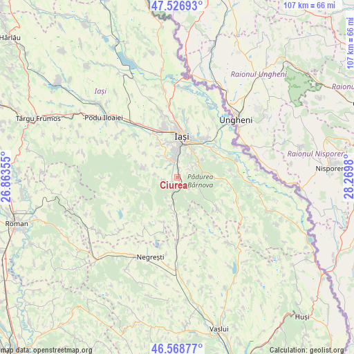
Ciurea GPS coordinates[2]
47° 3' 0" North, 27° 34' 0.012" East
| Map corner | latitude | longitude |
|---|---|---|
| Upper-left | 47.52693°, | 26.86355° |
| Center: | 47.05°, | 27.56667° |
| Lower-right: | 46.56877°, | 28.2698° |
| Map W x H: | 106.5×106.5 km | = 66.2×66.2mi |
| max Lat: | 48.23793° ⇑19.8% North |
| Ciurea: | 47.05° |
| min Lat: | ⇓80.2% South 43.65638° |
| min Long | Ciurea | max Long |
| 20.31667° | 27.56667° | 29.65403° |
| W 91.8%⇐ | ⇒8.2% E |
Elevation
Elevation of Ciurea is 92 m = 302 ft, and this is 162.9 m = 534 ft below average elevation for this country.
| Max E: |
1278 m = 4193 ft | 80.8% |
| Avg. | 254.9 m = 836 ft | |
| Ciurea | 92 m = 302 ft | |
Min E: |
-2 m = -7 ft | 19.2% |
See also: Romania elevation on elevation.city.
Geographical zone
Ciurea is located in North temperate zone (between Tropic of Cancer and the Arctic Circle). Distance of this North polar circle is 2169.7 km =1348.2 mi to North.| Distance of | km | miles | from Ciurea |
|---|---|---|---|
| North Pole | 4775.6 | 2967.4 | to North |
| Arctic Circle | 2169.7 | 1348.2 | to North |
| Tropic Cancer | 2625.6 | 1631.5 | to South |
| Equator | 5231.5 | 3250.7 | to South |


Nearby cities:
15 places around Ciurea: (largest is in red/bold)
• Bârnova
4.2 km =2.6 mi,  63°
63°
• Ciurbești
5.7 km =3.5 mi,  335°
335°
• Dumbrava
3.1 km =1.9 mi, 338°
• Grajduri
10 km =6.2 mi,  202°
202°
• Hadâmbu
9 km =5.6 mi,  245°
245°
• Horpaz
6.6 km =4.1 mi,  347°
347°
• Lunca Cetățuii
5.2 km =3.2 mi,  357°
357°
• Mogoşeşti
3.1 km =1.9 mi,  233°
233°
• Mânjești
7.8 km =4.8 mi,  283°
283°
• Picioru Lupului
1.6 km =1 mi,  146°
146°
• Poieni
10.1 km =6.3 mi,  90°
90°
• Protopopești
10.9 km =6.8 mi, 149°
• Păun
9.2 km =5.7 mi,  52°
52°
• Slobozia
5.1 km =3.2 mi,  133°
133°
• Valea Satului
10.8 km =6.7 mi,  187°
187°
Sources, notices
• [Note1] Compared only with cities in Romania existing in our database
• [Src1] Map data: © OpenStreetMap contributors (CC-BY-SA)
• [Src2] Other city data from geonames.org with taken over terms of usage.
• [Src3] Geographical zone / Annual Mean Temperature by Robert A. Rohde @ Wikipedia
