Bârca geodata
Bârca (Olt) is a populated place; located in Romania in Europe/Bucharest (GMT+3) time zone. With population of 941 people, there are 4483 cities with bigger population in this country. Compared to other cities in Romania, 86.6% of cities are located further ↑North; 60.8% of cities are located further →East and 59.8% of cities have higher elevation than Bârca. Note1


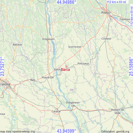
Bârca GPS coordinates[2]
44° 27' 0.288" North, 24° 27' 20.988" East
| Map corner | latitude | longitude |
|---|---|---|
| Upper-left | 44.94986°, | 23.75271° |
| Center: | 44.45008°, | 24.45583° |
| Lower-right: | 43.94599°, | 25.15896° |
| Map W x H: | 111.6×111.6 km | = 69.3×69.3mi |
| max Lat: | 48.23793° ⇑86.6% North |
| Bârca: | 44.45008° |
| min Lat: | ⇓13.4% South 43.65638° |
| min Long | Bârca | max Long |
| 20.31667° | 24.45583° | 29.65403° |
| W 39.2%⇐ | ⇒60.8% E |
Elevation
Elevation of Bârca is 167 m = 548 ft, and this is 87.9 m = 288 ft below average elevation for this country.
| Max E: |
1278 m = 4193 ft | 59.8% |
| Avg. | 254.9 m = 836 ft | |
| Bârca | 167 m = 548 ft | |
Min E: |
-2 m = -7 ft | 40.2% |
See also: Romania elevation on elevation.city.
Geographical zone
Bârca is located in North temperate zone (between Tropic of Cancer and the Arctic Circle). Distance of this Northern Tropic circle is 2336.5 km =1451.8 mi to South.| Distance of | km | miles | from Bârca |
|---|---|---|---|
| North Pole | 5064.7 | 3147.1 | to North |
| Arctic Circle | 2458.8 | 1527.8 | to North |
| Tropic Cancer | 2336.5 | 1451.8 | to South |
| Equator | 4942.4 | 3071.1 | to South |


Nearby cities:
15 places around Bârca: (largest is in red/bold)
• Brebeni
9.3 km =5.8 mi,  182°
182°
• Bălteni
6.1 km =3.8 mi,  91°
91°
• Cireașov
6.5 km =4 mi,  274°
274°
• Dobrotinet
9.2 km =5.7 mi,  290°
290°
• Linia din Vale
9.4 km =5.8 mi,  283°
283°
• Mierleștii de Sus
9.5 km =5.9 mi,  120°
120°
• Milcovu din Deal
8.1 km =5 mi,  220°
220°
• Măgura
10.1 km =6.3 mi,  128°
128°
• Perieţi
9.3 km =5.8 mi, 126°
• Pietrișu
9.4 km =5.8 mi, 294°
• Priseaca
7.4 km =4.6 mi,  356°
356°
• Proaspeți
9.4 km =5.8 mi, 276°
• Slatina
7.3 km =4.5 mi,  255°
255°
• Turia
1.8 km =1.1 mi,  102°
102°
• Valea Mare
2.6 km =1.6 mi,  315°
315°
Sources, notices
• [Note1] Compared only with cities in Romania existing in our database
• [Src1] Map data: © OpenStreetMap contributors (CC-BY-SA)
• [Src2] Other city data from geonames.org with taken over terms of usage.
• [Src3] Geographical zone / Annual Mean Temperature by Robert A. Rohde @ Wikipedia
