Biharia geodata
Biharia (Bihor) is a seat of a second-order administrative division; located in Romania in Europe/Bucharest (GMT+3) time zone. With population of 3,493 people, there are 1428 cities with bigger population in this country. Compared to other cities in Romania, 82.5% of cities are located further ↓South; 95.1% of cities are located further →East and 70.9% of cities have higher elevation than Biharia. Note1


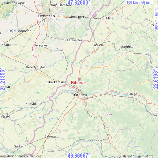
Biharia GPS coordinates[2]
47° 9' 0" North, 21° 55' 0.012" East
| Map corner | latitude | longitude |
|---|---|---|
| Upper-left | 47.62603°, | 21.21355° |
| Center: | 47.15°, | 21.91667° |
| Lower-right: | 46.66967°, | 22.6198° |
| Map W x H: | 106.3×106.3 km | = 66.1×66.1mi |
| max Lat: | 48.23793° ⇑17.5% North |
| Biharia: | 47.15° |
| min Lat: | ⇓82.5% South 43.65638° |
| min Long | Biharia | max Long |
| 20.31667° | 21.91667° | 29.65403° |
| W 4.9%⇐ | ⇒95.1% E |
Elevation
Elevation of Biharia is 124 m = 407 ft, and this is 130.9 m = 429 ft below average elevation for this country.
| Max E: |
1278 m = 4193 ft | 70.9% |
| Avg. | 254.9 m = 836 ft | |
| Biharia | 124 m = 407 ft | |
Min E: |
-2 m = -7 ft | 29.1% |
See also: Romania elevation on elevation.city.
Geographical zone
Biharia is located in North temperate zone (between Tropic of Cancer and the Arctic Circle). Distance of this North polar circle is 2158.6 km =1341.3 mi to North.| Distance of | km | miles | from Biharia |
|---|---|---|---|
| North Pole | 4764.5 | 2960.5 | to North |
| Arctic Circle | 2158.6 | 1341.3 | to North |
| Tropic Cancer | 2636.7 | 1638.4 | to South |
| Equator | 5242.6 | 3257.6 | to South |


Nearby cities:
15 places around Biharia: (largest is in red/bold)
• Borş
8.4 km =5.2 mi,  243°
243°
• Cauaceu
2.8 km =1.7 mi,  48°
48°
• Cetariu
7.8 km =4.8 mi,  103°
103°
• Hodoș
9.8 km =6.1 mi,  31°
31°
• Mihai Bravu
12.1 km =7.5 mi,  7°
7°
• Oradea
11.6 km =7.2 mi,  179°
179°
• Paleu
5 km =3.1 mi,  140°
140°
• Parhida
10 km =6.2 mi,  340°
340°
• Roșiori
12.2 km =7.6 mi, 12°
• Sântandrei
10.5 km =6.5 mi,  207°
207°
• Sântion
8.5 km =5.3 mi,  225°
225°
• Săldăbagiu de Munte
8 km =5 mi,  146°
146°
• Tămășeu
8 km =5 mi, 5°
• Uileacu de Munte
7.1 km =4.4 mi,  120°
120°
• Șișterea
12 km =7.5 mi,  84°
84°
Sources, notices
• [Note1] Compared only with cities in Romania existing in our database
• [Src1] Map data: © OpenStreetMap contributors (CC-BY-SA)
• [Src2] Other city data from geonames.org with taken over terms of usage.
• [Src3] Geographical zone / Annual Mean Temperature by Robert A. Rohde @ Wikipedia
