Oradea geodata
Oradea (Bihor) is a seat of a first-order administrative division; located in Romania in Europe/Bucharest (GMT+3) time zone. With population of 206,614 people, there are 16 cities with bigger population in this country. Compared to other cities in Romania, 80.1% of cities are located further ↓South; 95% of cities are located further →East and 71.2% of cities have higher elevation than Oradea. Note1


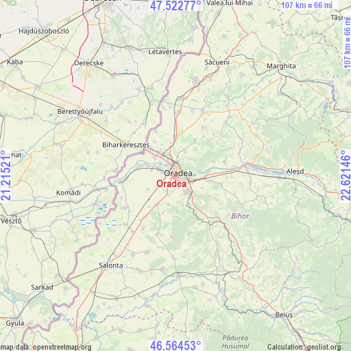
Oradea GPS coordinates[2]
47° 2' 44.88" North, 21° 55' 5.988" East
| Map corner | latitude | longitude |
|---|---|---|
| Upper-left | 47.52277°, | 21.21521° |
| Center: | 47.0458°, | 21.91833° |
| Lower-right: | 46.56453°, | 22.62146° |
| Map W x H: | 106.5×106.5 km | = 66.2×66.2mi |
| max Lat: | 48.23793° ⇑19.9% North |
| Oradea: | 47.0458° |
| min Lat: | ⇓80.1% South 43.65638° |
| min Long | Oradea | max Long |
| 20.31667° | 21.91833° | 29.65403° |
| W 5%⇐ | ⇒95% E |
Elevation
Elevation of Oradea is 123 m = 404 ft, and this is 131.9 m = 433 ft below average elevation for this country.
| Max E: |
1278 m = 4193 ft | 71.2% |
| Avg. | 254.9 m = 836 ft | |
| Oradea | 123 m = 404 ft | |
Min E: |
-2 m = -7 ft | 28.8% |
See also: Oradea elevation on elevation.city.
Geographical zone
Oradea is located in North temperate zone (between Tropic of Cancer and the Arctic Circle). Distance of this North polar circle is 2170.2 km =1348.5 mi to North.| Distance of | km | miles | from Oradea |
|---|---|---|---|
| North Pole | 4776.1 | 2967.7 | to North |
| Arctic Circle | 2170.2 | 1348.5 | to North |
| Tropic Cancer | 2625.1 | 1631.2 | to South |
| Equator | 5231 | 3250.4 | to South |


Nearby cities:
15 places around Oradea: (largest is in red/bold)
• Alparea
10 km =6.2 mi,  99°
99°
• Cheriu
8.7 km =5.4 mi,  115°
115°
• Cihei
5.9 km =3.7 mi,  153°
153°
• Fughiu
9.8 km =6.1 mi,  82°
82°
• Haieu
8.3 km =5.2 mi,  133°
133°
• Leș
10.8 km =6.7 mi,  213°
213°
• Livada de Bihor
9.2 km =5.7 mi,  244°
244°
• Nojorid
7.4 km =4.6 mi,  200°
200°
• Oșorhei
10.1 km =6.3 mi, 97°
• Paleu
8.3 km =5.2 mi,  21°
21°
• Sântandrei
5.4 km =3.4 mi,  294°
294°
• Sântion
8.4 km =5.2 mi,  312°
312°
• Sînmartin
6 km =3.7 mi,  135°
135°
• Săldăbagiu de Munte
6.5 km =4 mi,  41°
41°
• Uileacu de Munte
10 km =6.2 mi, 36°
Sources, notices
• [Note1] Compared only with cities in Romania existing in our database
• [Src1] Map data: © OpenStreetMap contributors (CC-BY-SA)
• [Src2] Other city data from geonames.org with taken over terms of usage.
• [Src3] Geographical zone / Annual Mean Temperature by Robert A. Rohde @ Wikipedia
