Band geodata
Band (Mureş) is a seat of a second-order administrative division; located in Romania in Europe/Bucharest (GMT+3) time zone. With population of 7,599 people, there are 348 cities with bigger population in this country. Compared to other cities in Romania, 69% of cities are located further ↓South; 62.1% of cities are located further →East and 75.6% of cities have lower elevation than Band. Note1


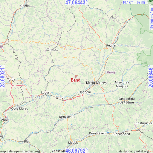
Band GPS coordinates[2]
46° 34' 59.988" North, 24° 22' 59.988" East
| Map corner | latitude | longitude |
|---|---|---|
| Upper-left | 47.06443°, | 23.68021° |
| Center: | 46.58333°, | 24.38333° |
| Lower-right: | 46.09792°, | 25.08646° |
| Map W x H: | 107.5×107.5 km | = 66.8×66.8mi |
| max Lat: | 48.23793° ⇑31% North |
| Band: | 46.58333° |
| min Lat: | ⇓69% South 43.65638° |
| min Long | Band | max Long |
| 20.31667° | 24.38333° | 29.65403° |
| W 37.9%⇐ | ⇒62.1% E |
Elevation
Elevation of Band is 358 m = 1175 ft, and this is 103.1 m = 338 ft above average elevation for this country.
| Max E: |
1278 m = 4193 ft | 24.4% |
| Band | 358 m 1175 ft | |
| Avg. | 254.9 m = 836 ft | |
Min E: |
-2 m = -7 ft | 75.6% |
See also: Romania elevation on elevation.city.
Geographical zone
Band is located in North temperate zone (between Tropic of Cancer and the Arctic Circle). Distance of this North polar circle is 2221.6 km =1380.4 mi to North.| Distance of | km | miles | from Band |
|---|---|---|---|
| North Pole | 4827.5 | 2999.7 | to North |
| Arctic Circle | 2221.6 | 1380.4 | to North |
| Tropic Cancer | 2573.7 | 1599.2 | to South |
| Equator | 5179.6 | 3218.5 | to South |


Nearby cities:
15 places around Band: (largest is in red/bold)
• Ceuașu de Câmpie
11.6 km =7.2 mi,  61°
61°
• Chirileu
11.9 km =7.4 mi,  180°
180°
• Cristeşti
12 km =7.5 mi,  140°
140°
• Grebenişu de Câmpie
6.6 km =4.1 mi,  286°
286°
• Iclandu Mare
10.9 km =6.8 mi,  235°
235°
• Iclănzel
9.5 km =5.9 mi,  233°
233°
• Mădăraș
4.6 km =2.9 mi, 58°
• Nazna
10.5 km =6.5 mi,  120°
120°
• Pănet
7.3 km =4.5 mi, 115°
• Remetea
10 km =6.2 mi,  95°
95°
• Râciu
11.2 km =7 mi,  6°
6°
• Sâncraiu de Mureş
11.5 km =7.1 mi,  108°
108°
• Săbed
10.2 km =6.3 mi,  28°
28°
• Vidrasău
12.2 km =7.6 mi,  168°
168°
• Şincai
7.4 km =4.6 mi,  0°
0°
Sources, notices
• [Note1] Compared only with cities in Romania existing in our database
• [Src1] Map data: © OpenStreetMap contributors (CC-BY-SA)
• [Src2] Other city data from geonames.org with taken over terms of usage.
• [Src3] Geographical zone / Annual Mean Temperature by Robert A. Rohde @ Wikipedia
