Pănet geodata
Pănet (Mureş) is a seat of a second-order administrative division; located in Romania in Europe/Bucharest (GMT+3) time zone. With population of 5,880 people, there are 563 cities with bigger population in this country. Compared to other cities in Romania, 68.4% of cities are located further ↓South; 60.6% of cities are located further →East and 69.7% of cities have lower elevation than Pănet. Note1


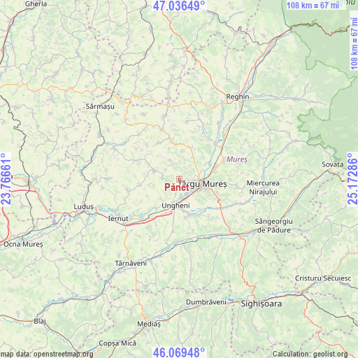
Pănet GPS coordinates[2]
46° 33' 18.504" North, 24° 28' 11.028" East
| Map corner | latitude | longitude |
|---|---|---|
| Upper-left | 47.03649°, | 23.76661° |
| Center: | 46.55514°, | 24.46973° |
| Lower-right: | 46.06948°, | 25.17286° |
| Map W x H: | 107.5×107.5 km | = 66.8×66.8mi |
| max Lat: | 48.23793° ⇑31.6% North |
| Pănet: | 46.55514° |
| min Lat: | ⇓68.4% South 43.65638° |
| min Long | Pănet | max Long |
| 20.31667° | 24.46973° | 29.65403° |
| W 39.4%⇐ | ⇒60.6% E |
Elevation
Elevation of Pănet is 318 m = 1043 ft, and this is 63.1 m = 207 ft above average elevation for this country.
| Max E: |
1278 m = 4193 ft | 30.3% |
| Pănet | 318 m 1043 ft | |
| Avg. | 254.9 m = 836 ft | |
Min E: |
-2 m = -7 ft | 69.7% |
See also: Romania elevation on elevation.city.
Geographical zone
Pănet is located in North temperate zone (between Tropic of Cancer and the Arctic Circle). Distance of this North polar circle is 2224.7 km =1382.4 mi to North.| Distance of | km | miles | from Pănet |
|---|---|---|---|
| North Pole | 4830.6 | 3001.6 | to North |
| Arctic Circle | 2224.7 | 1382.4 | to North |
| Tropic Cancer | 2570.5 | 1597.2 | to South |
| Equator | 5176.4 | 3216.5 | to South |


Nearby cities:
15 places around Pănet: (largest is in red/bold)
• Band
7.3 km =4.5 mi,  295°
295°
• Ceuașu de Câmpie
9.4 km =5.8 mi,  22°
22°
• Chinari
10.7 km =6.6 mi,  58°
58°
• Cristeşti
6.2 km =3.9 mi,  170°
170°
• Curteni
9.2 km =5.7 mi, 61°
• Gheorghe Doja
10.1 km =6.3 mi, 166°
• Mădăraș
6.2 km =3.9 mi,  334°
334°
• Nazna
3.3 km =2.1 mi,  131°
131°
• Remetea
4 km =2.5 mi, 57°
• Sâncraiu de Mureş
4.4 km =2.7 mi,  95°
95°
• Sângeorgiu de Mureş
9.7 km =6 mi,  80°
80°
• Sântana de Mureş
6.3 km =3.9 mi, 78°
• Târgu-Mureş
6.9 km =4.3 mi, 101°
• Ungheni
8 km =5 mi,  181°
181°
• Vidrasău
9.8 km =6.1 mi,  205°
205°
Sources, notices
• [Note1] Compared only with cities in Romania existing in our database
• [Src1] Map data: © OpenStreetMap contributors (CC-BY-SA)
• [Src2] Other city data from geonames.org with taken over terms of usage.
• [Src3] Geographical zone / Annual Mean Temperature by Robert A. Rohde @ Wikipedia
