Iclănzel geodata
Iclănzel (Mureş) is a seat of a second-order administrative division; located in Romania in Europe/Bucharest (GMT+3) time zone. With population of 2,255 people, there are 2365 cities with bigger population in this country. Compared to other cities in Romania, 67.8% of cities are located further ↓South; 64.2% of cities are located further →East and 68.6% of cities have lower elevation than Iclănzel. Note1


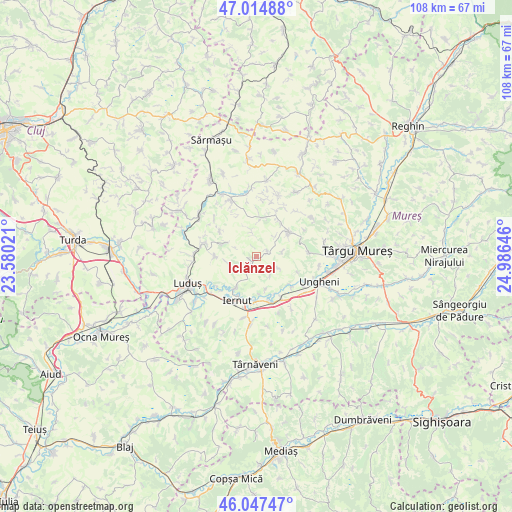
Iclănzel GPS coordinates[2]
46° 31' 59.988" North, 24° 16' 59.988" East
| Map corner | latitude | longitude |
|---|---|---|
| Upper-left | 47.01488°, | 23.58021° |
| Center: | 46.53333°, | 24.28333° |
| Lower-right: | 46.04747°, | 24.98646° |
| Map W x H: | 107.6×107.6 km | = 66.9×66.9mi |
| max Lat: | 48.23793° ⇑32.2% North |
| Iclănzel: | 46.53333° |
| min Lat: | ⇓67.8% South 43.65638° |
| min Long | Iclănzel | max Long |
| 20.31667° | 24.28333° | 29.65403° |
| W 35.8%⇐ | ⇒64.2% E |
Elevation
Elevation of Iclănzel is 310 m = 1017 ft, and this is 55.1 m = 181 ft above average elevation for this country.
| Max E: |
1278 m = 4193 ft | 31.4% |
| Iclănzel | 310 m 1017 ft | |
| Avg. | 254.9 m = 836 ft | |
Min E: |
-2 m = -7 ft | 68.6% |
See also: Romania elevation on elevation.city.
Geographical zone
Iclănzel is located in North temperate zone (between Tropic of Cancer and the Arctic Circle). Distance of this North polar circle is 2227.2 km =1383.9 mi to North.| Distance of | km | miles | from Iclănzel |
|---|---|---|---|
| North Pole | 4833 | 3003.1 | to North |
| Arctic Circle | 2227.2 | 1383.9 | to North |
| Tropic Cancer | 2568.1 | 1595.7 | to South |
| Equator | 5174 | 3215 | to South |


Nearby cities:
15 places around Iclănzel: (largest is in red/bold)
• Band
9.5 km =5.9 mi,  53°
53°
• Bârza
11.6 km =7.2 mi,  279°
279°
• Chirileu
9.9 km =6.2 mi,  129°
129°
• Cipăieni
8.9 km =5.5 mi,  269°
269°
• Cipău
9.4 km =5.8 mi,  182°
182°
• Grebenişu de Câmpie
7.5 km =4.7 mi,  9°
9°
• Iclandu Mare
1.5 km =0.9 mi,  247°
247°
• Iernut
9.6 km =6 mi,  195°
195°
• Lechința
7.8 km =4.8 mi,  212°
212°
• Ogra
11.4 km =7.1 mi,  167°
167°
• Papiu Ilarian
6.6 km =4.1 mi,  286°
286°
• Sânger
11.5 km =7.1 mi, 283°
• Sânpaul
10.6 km =6.6 mi,  151°
151°
• Vidrasău
12 km =7.5 mi,  122°
122°
• Şăulia
12.2 km =7.6 mi,  335°
335°
Sources, notices
• [Note1] Compared only with cities in Romania existing in our database
• [Src1] Map data: © OpenStreetMap contributors (CC-BY-SA)
• [Src2] Other city data from geonames.org with taken over terms of usage.
• [Src3] Geographical zone / Annual Mean Temperature by Robert A. Rohde @ Wikipedia
