Bălăşeşti geodata
Bălăşeşti (Galaţi) is a seat of a second-order administrative division; located in Romania in Europe/Bucharest (GMT+3) time zone. With population of 2,534 people, there are 2131 cities with bigger population in this country. Compared to other cities in Romania, 57.2% of cities are located further ↓South; 92.8% of cities are located further ←West and 67.4% of cities have higher elevation than Bălăşeşti. Note1


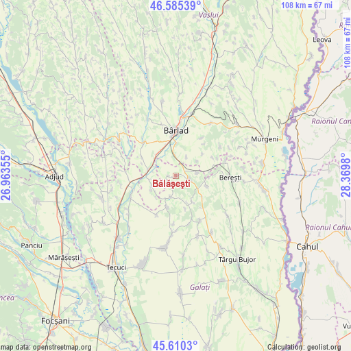
Bălăşeşti GPS coordinates[2]
46° 6' 0" North, 27° 40' 0.012" East
| Map corner | latitude | longitude |
|---|---|---|
| Upper-left | 46.58539°, | 26.96355° |
| Center: | 46.1°, | 27.66667° |
| Lower-right: | 45.6103°, | 28.3698° |
| Map W x H: | 108.4×108.4 km | = 67.4×67.4mi |
| max Lat: | 48.23793° ⇑42.8% North |
| Bălăşeşti: | 46.1° |
| min Lat: | ⇓57.2% South 43.65638° |
| min Long | Bălăşeşti | max Long |
| 20.31667° | 27.66667° | 29.65403° |
| W 92.8%⇐ | ⇒7.2% E |
Elevation
Elevation of Bălăşeşti is 137 m = 449 ft, and this is 117.9 m = 387 ft below average elevation for this country.
| Max E: |
1278 m = 4193 ft | 67.4% |
| Avg. | 254.9 m = 836 ft | |
| Bălăşeşti | 137 m = 449 ft | |
Min E: |
-2 m = -7 ft | 32.6% |
See also: Romania elevation on elevation.city.
Geographical zone
Bălăşeşti is located in North temperate zone (between Tropic of Cancer and the Arctic Circle). Distance of this North polar circle is 2275.3 km =1413.8 mi to North.| Distance of | km | miles | from Bălăşeşti |
|---|---|---|---|
| North Pole | 4881.2 | 3033 | to North |
| Arctic Circle | 2275.3 | 1413.8 | to North |
| Tropic Cancer | 2519.9 | 1565.8 | to South |
| Equator | 5125.8 | 3185 | to South |


Nearby cities:
15 places around Bălăşeşti: (largest is in red/bold)
• Adam
9.4 km =5.8 mi,  147°
147°
• Bădeana
8.5 km =5.3 mi,  310°
310°
• Bălăbănești
4.3 km =2.7 mi,  96°
96°
• Cerţeşti
10 km =6.2 mi,  202°
202°
• Ciurești
3.4 km =2.1 mi,  225°
225°
• Ciureștii Noi
2.1 km =1.3 mi,  272°
272°
• Cotoroaia
6.4 km =4 mi,  194°
194°
• Docani
8 km =5 mi,  55°
55°
• Griviţa
5.7 km =3.5 mi,  346°
346°
• Lungești
6.8 km =4.2 mi,  81°
81°
• Odaia Bursucani
6.8 km =4.2 mi,  30°
30°
• Pochidia
8.8 km =5.5 mi,  224°
224°
• Rădești
9.9 km =6.2 mi,  107°
107°
• Sălceni
8.5 km =5.3 mi,  242°
242°
• Tutova
9.2 km =5.7 mi,  281°
281°
Sources, notices
• [Note1] Compared only with cities in Romania existing in our database
• [Src1] Map data: © OpenStreetMap contributors (CC-BY-SA)
• [Src2] Other city data from geonames.org with taken over terms of usage.
• [Src3] Geographical zone / Annual Mean Temperature by Robert A. Rohde @ Wikipedia
