Tutova geodata
Tutova (Vaslui) is a seat of a second-order administrative division; located in Romania in Europe/Bucharest (GMT+3) time zone. With population of 5,619 people, there are 615 cities with bigger population in this country. Compared to other cities in Romania, 57.7% of cities are located further ↓South; 91.6% of cities are located further ←West and 90.9% of cities have higher elevation than Tutova. Note1


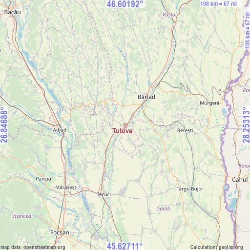
Tutova GPS coordinates[2]
46° 7' 0.012" North, 27° 33' 0" East
| Map corner | latitude | longitude |
|---|---|---|
| Upper-left | 46.60192°, | 26.84688° |
| Center: | 46.11667°, | 27.55° |
| Lower-right: | 45.62711°, | 28.25313° |
| Map W x H: | 108.4×108.4 km | = 67.4×67.4mi |
| max Lat: | 48.23793° ⇑42.3% North |
| Tutova: | 46.11667° |
| min Lat: | ⇓57.7% South 43.65638° |
| min Long | Tutova | max Long |
| 20.31667° | 27.55° | 29.65403° |
| W 91.6%⇐ | ⇒8.4% E |
Elevation
Elevation of Tutova is 54 m = 177 ft, and this is 200.9 m = 659 ft below average elevation for this country.
| Max E: |
1278 m = 4193 ft | 90.9% |
| Avg. | 254.9 m = 836 ft | |
| Tutova | 54 m = 177 ft | |
Min E: |
-2 m = -7 ft | 9.1% |
See also: Romania elevation on elevation.city.
Geographical zone
Tutova is located in North temperate zone (between Tropic of Cancer and the Arctic Circle). Distance of this North polar circle is 2273.5 km =1412.7 mi to North.| Distance of | km | miles | from Tutova |
|---|---|---|---|
| North Pole | 4879.4 | 3031.9 | to North |
| Arctic Circle | 2273.5 | 1412.7 | to North |
| Tropic Cancer | 2521.8 | 1567 | to South |
| Equator | 5127.7 | 3186.2 | to South |


Nearby cities:
15 places around Tutova: (largest is in red/bold)
• Bădeana
4.5 km =2.8 mi,  34°
34°
• Bălăşeşti
9.2 km =5.7 mi,  101°
101°
• Ciorăști
7.5 km =4.7 mi,  267°
267°
• Ciurești
7.8 km =4.8 mi,  122°
122°
• Ciureștii Noi
7.1 km =4.4 mi, 104°
• Cotoroaia
10.9 km =6.8 mi,  137°
137°
• Gefu
5.3 km =3.3 mi,  209°
209°
• Ghidigeni
8.4 km =5.2 mi, 207°
• Griviţa
8.6 km =5.3 mi,  64°
64°
• Iveşti
7.5 km =4.7 mi,  350°
350°
• Pochidia
8.7 km =5.4 mi,  160°
160°
• Pogonești
4.2 km =2.6 mi,  340°
340°
• Priponeşti
9.7 km =6 mi,  247°
247°
• Sălceni
5.9 km =3.7 mi,  165°
165°
• Trestiana
12 km =7.5 mi,  39°
39°
Sources, notices
• [Note1] Compared only with cities in Romania existing in our database
• [Src1] Map data: © OpenStreetMap contributors (CC-BY-SA)
• [Src2] Other city data from geonames.org with taken over terms of usage.
• [Src3] Geographical zone / Annual Mean Temperature by Robert A. Rohde @ Wikipedia
