Sălceni geodata
Sălceni (Vaslui) is a populated place; located in Romania in Europe/Bucharest (GMT+3) time zone. With population of 875 people, there are 4730 cities with bigger population in this country. Compared to other cities in Romania, 56.3% of cities are located further ↓South; 91.9% of cities are located further ←West and 79.6% of cities have higher elevation than Sălceni. Note1


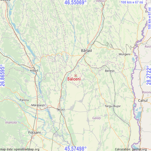
Sălceni GPS coordinates[2]
46° 3' 53.964" North, 27° 34' 8.652" East
| Map corner | latitude | longitude |
|---|---|---|
| Upper-left | 46.55069°, | 26.86595° |
| Center: | 46.06499°, | 27.56907° |
| Lower-right: | 45.57498°, | 28.2722° |
| Map W x H: | 108.5×108.5 km | = 67.4×67.4mi |
| max Lat: | 48.23793° ⇑43.7% North |
| Sălceni: | 46.06499° |
| min Lat: | ⇓56.3% South 43.65638° |
| min Long | Sălceni | max Long |
| 20.31667° | 27.56907° | 29.65403° |
| W 91.9%⇐ | ⇒8.1% E |
Elevation
Elevation of Sălceni is 96 m = 315 ft, and this is 158.9 m = 521 ft below average elevation for this country.
| Max E: |
1278 m = 4193 ft | 79.6% |
| Avg. | 254.9 m = 836 ft | |
| Sălceni | 96 m = 315 ft | |
Min E: |
-2 m = -7 ft | 20.4% |
See also: Romania elevation on elevation.city.
Geographical zone
Sălceni is located in North temperate zone (between Tropic of Cancer and the Arctic Circle). Distance of this North polar circle is 2279.2 km =1416.2 mi to North.| Distance of | km | miles | from Sălceni |
|---|---|---|---|
| North Pole | 4885.1 | 3035.5 | to North |
| Arctic Circle | 2279.2 | 1416.2 | to North |
| Tropic Cancer | 2516 | 1563.4 | to South |
| Equator | 5121.9 | 3182.6 | to South |


Nearby cities:
15 places around Sălceni: (largest is in red/bold)
• Bădeana
9.5 km =5.9 mi,  6°
6°
• Bălăşeşti
8.5 km =5.3 mi,  62°
62°
• Cerţeşti
6.5 km =4 mi,  145°
145°
• Ciorăști
10.5 km =6.5 mi,  301°
301°
• Ciurești
5.4 km =3.4 mi,  73°
73°
• Ciureștii Noi
6.7 km =4.2 mi,  53°
53°
• Cotoroaia
6.4 km =4 mi,  111°
111°
• Cârlomănești
9.1 km =5.7 mi,  173°
173°
• Gefu
4.2 km =2.6 mi,  284°
284°
• Ghidigeni
5.6 km =3.5 mi,  252°
252°
• Pochidia
2.8 km =1.7 mi, 149°
• Pogonești
10.1 km =6.3 mi,  343°
343°
• Slobozia Corni
10.6 km =6.6 mi,  220°
220°
• Tutova
5.9 km =3.7 mi,  345°
345°
• Tălpigi
9.8 km =6.1 mi,  229°
229°
Sources, notices
• [Note1] Compared only with cities in Romania existing in our database
• [Src1] Map data: © OpenStreetMap contributors (CC-BY-SA)
• [Src2] Other city data from geonames.org with taken over terms of usage.
• [Src3] Geographical zone / Annual Mean Temperature by Robert A. Rohde @ Wikipedia
