Bala geodata
Bala (Mehedinţi) is a seat of a second-order administrative division; located in Romania in Europe/Bucharest (GMT+3) time zone. With population of 4,580 people, there are 928 cities with bigger population in this country. Compared to other cities in Romania, 73.6% of cities are located further ↑North; 86.7% of cities are located further →East and 53.8% of cities have lower elevation than Bala. Note1


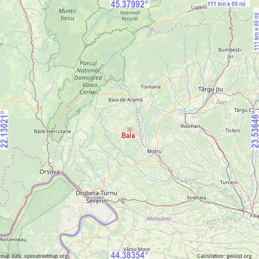
Bala GPS coordinates[2]
44° 53' 2.004" North, 22° 49' 59.988" East
| Map corner | latitude | longitude |
|---|---|---|
| Upper-left | 45.37992°, | 22.13021° |
| Center: | 44.88389°, | 22.83333° |
| Lower-right: | 44.38354°, | 23.53646° |
| Map W x H: | 110.8×110.8 km | = 68.8×68.8mi |
| max Lat: | 48.23793° ⇑73.6% North |
| Bala: | 44.88389° |
| min Lat: | ⇓26.4% South 43.65638° |
| min Long | Bala | max Long |
| 20.31667° | 22.83333° | 29.65403° |
| W 13.3%⇐ | ⇒86.7% E |
Elevation
Elevation of Bala is 232 m = 761 ft, and this is 22.9 m = 75 ft below average elevation for this country.
| Max E: |
1278 m = 4193 ft | 46.2% |
| Avg. | 254.9 m = 836 ft | |
| Bala | 232 m = 761 ft | |
Min E: |
-2 m = -7 ft | 53.8% |
See also: Romania elevation on elevation.city.
Geographical zone
Bala is located in North temperate zone (between Tropic of Cancer and the Arctic Circle). Distance of this Northern Tropic circle is 2384.7 km =1481.8 mi to South.| Distance of | km | miles | from Bala |
|---|---|---|---|
| North Pole | 5016.4 | 3117 | to North |
| Arctic Circle | 2410.6 | 1497.9 | to North |
| Tropic Cancer | 2384.7 | 1481.8 | to South |
| Equator | 4990.6 | 3101 | to South |


Nearby cities:
15 places around Bala: (largest is in red/bold)
• Baia de Aramă
13 km =8.1 mi,  351°
351°
• Bala de Sus
2.2 km =1.4 mi,  315°
315°
• Cătunele
6.2 km =3.9 mi,  110°
110°
• Glogova
7.6 km =4.7 mi,  49°
49°
• Ilovăț
9.7 km =6 mi,  214°
214°
• Lupoaia
12.7 km =7.9 mi,  127°
127°
• Negoești
11.2 km =7 mi,  11°
11°
• Noapteșa
9.6 km =6 mi,  163°
163°
• Olteanu
6.8 km =4.2 mi,  88°
88°
• Ponoarele
11.4 km =7.1 mi,  331°
331°
• Roșiuța
11.9 km =7.4 mi,  104°
104°
• Rudina
3 km =1.9 mi,  261°
261°
• Zegujani
10.6 km =6.6 mi,  142°
142°
• Şişeşti
11.8 km =7.3 mi,  177°
177°
• Şovarna
4.7 km =2.9 mi,  223°
223°
Sources, notices
• [Note1] Compared only with cities in Romania existing in our database
• [Src1] Map data: © OpenStreetMap contributors (CC-BY-SA)
• [Src2] Other city data from geonames.org with taken over terms of usage.
• [Src3] Geographical zone / Annual Mean Temperature by Robert A. Rohde @ Wikipedia
