Cătunele geodata
Cătunele (Gorj) is a seat of a second-order administrative division; located in Romania in Europe/Bucharest (GMT+3) time zone. With population of 375 people, there are 7043 cities with bigger population in this country. Compared to other cities in Romania, 74.5% of cities are located further ↑North; 85.8% of cities are located further →East and 51.2% of cities have higher elevation than Cătunele. Note1


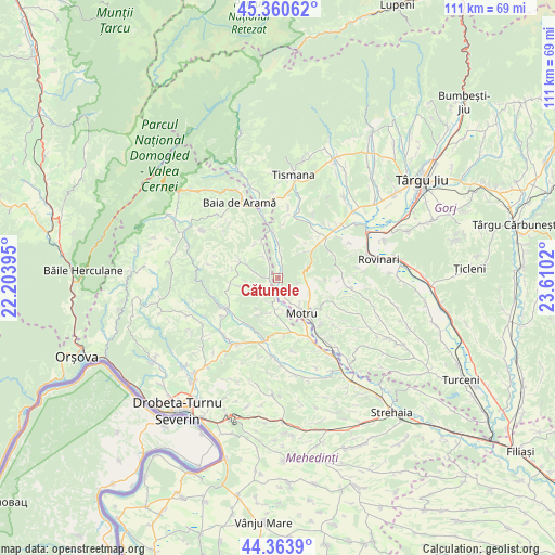
Cătunele GPS coordinates[2]
44° 51' 51.912" North, 22° 54' 25.452" East
| Map corner | latitude | longitude |
|---|---|---|
| Upper-left | 45.36062°, | 22.20395° |
| Center: | 44.86442°, | 22.90707° |
| Lower-right: | 44.3639°, | 23.6102° |
| Map W x H: | 110.8×110.8 km | = 68.8×68.8mi |
| max Lat: | 48.23793° ⇑74.5% North |
| Cătunele: | 44.86442° |
| min Lat: | ⇓25.5% South 43.65638° |
| min Long | Cătunele | max Long |
| 20.31667° | 22.90707° | 29.65403° |
| W 14.2%⇐ | ⇒85.8% E |
Elevation
Elevation of Cătunele is 205 m = 673 ft, and this is 49.9 m = 164 ft below average elevation for this country.
| Max E: |
1278 m = 4193 ft | 51.2% |
| Avg. | 254.9 m = 836 ft | |
| Cătunele | 205 m = 673 ft | |
Min E: |
-2 m = -7 ft | 48.8% |
See also: Romania elevation on elevation.city.
Geographical zone
Cătunele is located in North temperate zone (between Tropic of Cancer and the Arctic Circle). Distance of this Northern Tropic circle is 2382.5 km =1480.4 mi to South.| Distance of | km | miles | from Cătunele |
|---|---|---|---|
| North Pole | 5018.6 | 3118.4 | to North |
| Arctic Circle | 2412.7 | 1499.2 | to North |
| Tropic Cancer | 2382.5 | 1480.4 | to South |
| Equator | 4988.5 | 3099.7 | to South |


Nearby cities:
15 places around Cătunele: (largest is in red/bold)
• Bala
6.2 km =3.9 mi,  290°
290°
• Bala de Sus
8.3 km =5.2 mi,  297°
297°
• Glogova
7.1 km =4.4 mi,  359°
359°
• Lupoaia
7 km =4.3 mi,  142°
142°
• Meriș
10.7 km =6.6 mi,  148°
148°
• Motru
8.5 km =5.3 mi, 143°
• Noapteșa
7.7 km =4.8 mi,  203°
203°
• Olteanu
2.6 km =1.6 mi,  23°
23°
• Ploștina
7.8 km =4.8 mi,  125°
125°
• Roșiuța
5.8 km =3.6 mi,  97°
97°
• Rudina
9 km =5.6 mi,  280°
280°
• Runcurel
8.9 km =5.5 mi,  93°
93°
• Zegujani
6.2 km =3.9 mi,  174°
174°
• Şişeşti
11 km =6.8 mi,  208°
208°
• Şovarna
9.1 km =5.7 mi,  262°
262°
Sources, notices
• [Note1] Compared only with cities in Romania existing in our database
• [Src1] Map data: © OpenStreetMap contributors (CC-BY-SA)
• [Src2] Other city data from geonames.org with taken over terms of usage.
• [Src3] Geographical zone / Annual Mean Temperature by Robert A. Rohde @ Wikipedia
