Avram Iancu geodata
Avram Iancu (Alba) is a seat of a second-order administrative division; located in Romania in Europe/Bucharest (GMT+3) time zone. With population of 1,806 people, there are 2820 cities with bigger population in this country. Compared to other cities in Romania, 64.1% of cities are located further ↓South; 87.4% of cities are located further →East and 98.8% of cities have lower elevation than Avram Iancu. Note1


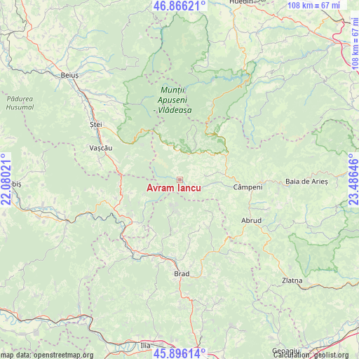
Avram Iancu GPS coordinates[2]
46° 22' 59.988" North, 22° 46' 59.988" East
| Map corner | latitude | longitude |
|---|---|---|
| Upper-left | 46.86621°, | 22.08021° |
| Center: | 46.38333°, | 22.78333° |
| Lower-right: | 45.89614°, | 23.48646° |
| Map W x H: | 107.9×107.9 km | = 67×67mi |
| max Lat: | 48.23793° ⇑35.9% North |
| Avram Iancu: | 46.38333° |
| min Lat: | ⇓64.1% South 43.65638° |
| min Long | Avram Iancu | max Long |
| 20.31667° | 22.78333° | 29.65403° |
| W 12.6%⇐ | ⇒87.4% E |
Elevation
Elevation of Avram Iancu is 837 m = 2746 ft, and this is 582.1 m = 1910 ft above average elevation for this country.
| Max E: |
1278 m = 4193 ft | 1.2% |
| Avram Iancu | 837 m 2746 ft | |
| Avg. | 254.9 m = 836 ft | |
Min E: |
-2 m = -7 ft | 98.8% |
See also: Romania elevation on elevation.city.
Geographical zone
Avram Iancu is located in North temperate zone (between Tropic of Cancer and the Arctic Circle). Distance of this North polar circle is 2243.8 km =1394.2 mi to North.| Distance of | km | miles | from Avram Iancu |
|---|---|---|---|
| North Pole | 4849.7 | 3013.5 | to North |
| Arctic Circle | 2243.8 | 1394.2 | to North |
| Tropic Cancer | 2551.4 | 1585.4 | to South |
| Equator | 5157.3 | 3204.6 | to South |


Nearby cities:
15 places around Avram Iancu: (largest is in red/bold)
• Albac
15 km =9.3 mi,  59°
59°
• Arieşeni
10.5 km =6.5 mi,  349°
349°
• Bulzeștii de Sus
9.3 km =5.8 mi,  190°
190°
• Băița
18.7 km =11.6 mi,  305°
305°
• Gârda de Sus
7.8 km =4.8 mi,  19°
19°
• Horea
18.4 km =11.4 mi,  44°
44°
• Hălmăgel
18.2 km =11.3 mi,  224°
224°
• Lazuri
17.7 km =11 mi,  255°
255°
• Luncșoara
13.8 km =8.6 mi,  239°
239°
• Poiana
17.2 km =10.7 mi,  294°
294°
• Poiana Vadului
7.9 km =4.9 mi,  76°
76°
• Rișculița
18.1 km =11.2 mi,  195°
195°
• Scărişoara
10.6 km =6.6 mi,  28°
28°
• Vadu Moţilor
14.2 km =8.8 mi, 82°
• Vidra
8.2 km =5.1 mi,  102°
102°
Sources, notices
• [Note1] Compared only with cities in Romania existing in our database
• [Src1] Map data: © OpenStreetMap contributors (CC-BY-SA)
• [Src2] Other city data from geonames.org with taken over terms of usage.
• [Src3] Geographical zone / Annual Mean Temperature by Robert A. Rohde @ Wikipedia
