Rișculița geodata
Rișculița (Hunedoara) is a populated place; located in Romania in Europe/Bucharest (GMT+3) time zone. With population of 551 people, there are 6574 cities with bigger population in this country. Compared to other cities in Romania, 60.2% of cities are located further ↓South; 87.9% of cities are located further →East and 63.4% of cities have lower elevation than Rișculița. Note1


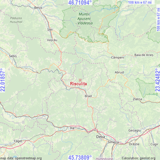
Rișculița GPS coordinates[2]
46° 13' 36.012" North, 22° 43' 18.084" East
| Map corner | latitude | longitude |
|---|---|---|
| Upper-left | 46.71094°, | 22.01857° |
| Center: | 46.22667°, | 22.72169° |
| Lower-right: | 45.73809°, | 23.42482° |
| Map W x H: | 108.2×108.2 km | = 67.2×67.2mi |
| max Lat: | 48.23793° ⇑39.8% North |
| Rișculița: | 46.22667° |
| min Lat: | ⇓60.2% South 43.65638° |
| min Long | Rișculița | max Long |
| 20.31667° | 22.72169° | 29.65403° |
| W 12.1%⇐ | ⇒87.9% E |
Elevation
Elevation of Rișculița is 281 m = 922 ft, and this is 26.1 m = 86 ft above average elevation for this country.
| Max E: |
1278 m = 4193 ft | 36.6% |
| Rișculița | 281 m 922 ft | |
| Avg. | 254.9 m = 836 ft | |
Min E: |
-2 m = -7 ft | 63.4% |
See also: Romania elevation on elevation.city.
Geographical zone
Rișculița is located in North temperate zone (between Tropic of Cancer and the Arctic Circle). Distance of this North polar circle is 2261.3 km =1405.1 mi to North.| Distance of | km | miles | from Rișculița |
|---|---|---|---|
| North Pole | 4867.1 | 3024.3 | to North |
| Arctic Circle | 2261.3 | 1405.1 | to North |
| Tropic Cancer | 2534 | 1574.6 | to South |
| Equator | 5139.9 | 3193.8 | to South |


Nearby cities:
15 places around Rișculița: (largest is in red/bold)
• Baia de Criş
6.7 km =4.2 mi,  183°
183°
• Blăjeni
13.7 km =8.5 mi,  86°
86°
• Brad
11.4 km =7.1 mi,  155°
155°
• Bulzeștii de Sus
8.8 km =5.5 mi,  20°
20°
• Crișan
8.6 km =5.3 mi,  136°
136°
• Hălmagiu
11.5 km =7.1 mi,  292°
292°
• Hălmăgel
9.2 km =5.7 mi,  298°
298°
• Luncșoara
12.7 km =7.9 mi,  325°
325°
• Mesteacăn
9.8 km =6.1 mi, 161°
• Ribiţa
5.9 km =3.7 mi, 144°
• Tomeşti
5.6 km =3.5 mi,  258°
258°
• Valea Bradului
11.8 km =7.3 mi, 135°
• Vaţa de Jos
10.5 km =6.5 mi,  242°
242°
• Zdrapți
13.8 km =8.6 mi,  124°
124°
• Țebea
7.4 km =4.6 mi, 180°
Sources, notices
• [Note1] Compared only with cities in Romania existing in our database
• [Src1] Map data: © OpenStreetMap contributors (CC-BY-SA)
• [Src2] Other city data from geonames.org with taken over terms of usage.
• [Src3] Geographical zone / Annual Mean Temperature by Robert A. Rohde @ Wikipedia
