Avântu geodata
Avântu (Iaşi) is a populated place; located in Romania in Europe/Bucharest (GMT+3) time zone. With population of 579 people, there are 6363 cities with bigger population in this country. Compared to other cities in Romania, 85.6% of cities are located further ↓South; 89.3% of cities are located further ←West and 78% of cities have higher elevation than Avântu. Note1


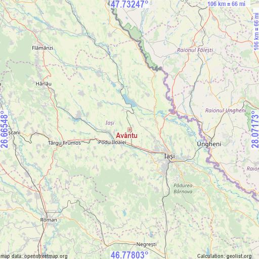
Avântu GPS coordinates[2]
47° 15' 26.64" North, 27° 22' 6.96" East
| Map corner | latitude | longitude |
|---|---|---|
| Upper-left | 47.73247°, | 26.66548° |
| Center: | 47.2574°, | 27.3686° |
| Lower-right: | 46.77803°, | 28.07173° |
| Map W x H: | 106.1×106.1 km | = 65.9×65.9mi |
| max Lat: | 48.23793° ⇑14.4% North |
| Avântu: | 47.2574° |
| min Lat: | ⇓85.6% South 43.65638° |
| min Long | Avântu | max Long |
| 20.31667° | 27.3686° | 29.65403° |
| W 89.3%⇐ | ⇒10.7% E |
Elevation
Elevation of Avântu is 101 m = 331 ft, and this is 153.9 m = 505 ft below average elevation for this country.
| Max E: |
1278 m = 4193 ft | 78% |
| Avg. | 254.9 m = 836 ft | |
| Avântu | 101 m = 331 ft | |
Min E: |
-2 m = -7 ft | 22% |
See also: Romania elevation on elevation.city.
Geographical zone
Avântu is located in North temperate zone (between Tropic of Cancer and the Arctic Circle). Distance of this North polar circle is 2146.6 km =1333.8 mi to North.| Distance of | km | miles | from Avântu |
|---|---|---|---|
| North Pole | 4752.5 | 2953.1 | to North |
| Arctic Circle | 2146.6 | 1333.8 | to North |
| Tropic Cancer | 2648.6 | 1645.8 | to South |
| Equator | 5254.5 | 3265 | to South |


Nearby cities:
15 places around Avântu: (largest is in red/bold)
• Bogonos
7.3 km =4.5 mi,  137°
137°
• Cogeasca
10.2 km =6.3 mi,  172°
172°
• Dumeşti
8.4 km =5.2 mi,  189°
189°
• Erbiceni
10.3 km =6.4 mi,  275°
275°
• Hoisești
7.5 km =4.7 mi,  205°
205°
• Iepureni
6.9 km =4.3 mi,  46°
46°
• Larga-Jijia
7.2 km =4.5 mi,  11°
11°
• Leţcani
9 km =5.6 mi,  156°
156°
• Mihail Kogălniceanu
10.6 km =6.6 mi,  19°
19°
• Movileni
6.7 km =4.2 mi,  347°
347°
• Podu Iloaiei
8.9 km =5.5 mi,  239°
239°
• Potângeni
8.4 km =5.2 mi,  343°
343°
• Româneşti
4.9 km =3 mi,  306°
306°
• Totoești
6.1 km =3.8 mi,  263°
263°
• Tăutești
7.7 km =4.8 mi,  110°
110°
Sources, notices
• [Note1] Compared only with cities in Romania existing in our database
• [Src1] Map data: © OpenStreetMap contributors (CC-BY-SA)
• [Src2] Other city data from geonames.org with taken over terms of usage.
• [Src3] Geographical zone / Annual Mean Temperature by Robert A. Rohde @ Wikipedia
