Urziceni geodata
Urziceni (Ialomiţa) is a seat of a second-order administrative division; located in Romania in Europe/Bucharest (GMT+3) time zone. With population of 16,770 people, there are 119 cities with bigger population in this country. Compared to other cities in Romania, 79.7% of cities are located further ↑North; 75.2% of cities are located further ←West and 91.3% of cities have higher elevation than Urziceni. Note1


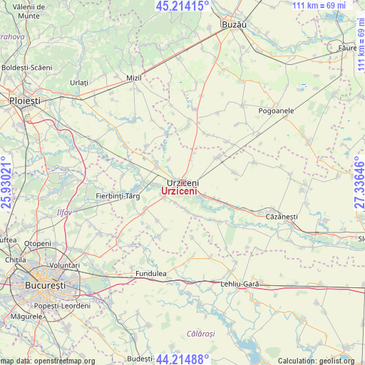
Urziceni GPS coordinates[2]
44° 43' 0.012" North, 26° 37' 59.988" East
| Map corner | latitude | longitude |
|---|---|---|
| Upper-left | 45.21415°, | 25.93021° |
| Center: | 44.71667°, | 26.63333° |
| Lower-right: | 44.21488°, | 27.33646° |
| Map W x H: | 111.1×111.1 km | = 69×69mi |
| max Lat: | 48.23793° ⇑79.7% North |
| Urziceni: | 44.71667° |
| min Lat: | ⇓20.3% South 43.65638° |
| min Long | Urziceni | max Long |
| 20.31667° | 26.63333° | 29.65403° |
| W 75.2%⇐ | ⇒24.8% E |
Elevation
Elevation of Urziceni is 52 m = 171 ft, and this is 202.9 m = 666 ft below average elevation for this country.
| Max E: |
1278 m = 4193 ft | 91.3% |
| Avg. | 254.9 m = 836 ft | |
| Urziceni | 52 m = 171 ft | |
Min E: |
-2 m = -7 ft | 8.7% |
See also: Romania elevation on elevation.city.
Geographical zone
Urziceni is located in North temperate zone (between Tropic of Cancer and the Arctic Circle). Distance of this Northern Tropic circle is 2366.1 km =1470.2 mi to South.| Distance of | km | miles | from Urziceni |
|---|---|---|---|
| North Pole | 5035 | 3128.6 | to North |
| Arctic Circle | 2429.1 | 1509.4 | to North |
| Tropic Cancer | 2366.1 | 1470.2 | to South |
| Equator | 4972 | 3089.5 | to South |


Nearby cities:
15 places around Urziceni: (largest is in red/bold)
• Alexeni
6.4 km =4 mi,  125°
125°
• Armăşeşti
5.4 km =3.4 mi,  313°
313°
• Borănești
6.6 km =4.1 mi,  199°
199°
• Broșteni
10.3 km =6.4 mi,  118°
118°
• Bărbulești
2.9 km =1.8 mi,  291°
291°
• Bărcăneşti
9.4 km =5.8 mi,  171°
171°
• Ciocârlia
9.6 km =6 mi,  15°
15°
• Condeești
10.9 km =6.8 mi,  155°
155°
• Coşereni
6.4 km =4 mi,  234°
234°
• Ion Roată
11.9 km =7.4 mi, 117°
• Jilavele
9.7 km =6 mi, 305°
• Malu Roșu
8.3 km =5.2 mi,  329°
329°
• Manasia
3.2 km =2 mi, 125°
• Moldoveni
9.1 km =5.7 mi,  268°
268°
• Slătioarele
12 km =7.5 mi, 310°
Sources, notices
• [Note1] Compared only with cities in Romania existing in our database
• [Src1] Map data: © OpenStreetMap contributors (CC-BY-SA)
• [Src2] Other city data from geonames.org with taken over terms of usage.
• [Src3] Geographical zone / Annual Mean Temperature by Robert A. Rohde @ Wikipedia
