Andreești geodata
Andreești (Gorj) is a seat of a second-order administrative division; located in Romania in Europe/Bucharest (GMT+3) time zone. With population of 972 people, there are 4378 cities with bigger population in this country. Compared to other cities in Romania, 77% of cities are located further ↑North; 76.3% of cities are located further →East and 59.5% of cities have higher elevation than Andreești. Note1


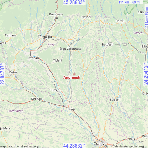
Andreești GPS coordinates[2]
44° 47' 22.128" North, 23° 33' 3.564" East
| Map corner | latitude | longitude |
|---|---|---|
| Upper-left | 45.28633°, | 22.84787° |
| Center: | 44.78948°, | 23.55099° |
| Lower-right: | 44.28832°, | 24.25412° |
| Map W x H: | 111×111 km | = 69×69mi |
| max Lat: | 48.23793° ⇑77% North |
| Andreești: | 44.78948° |
| min Lat: | ⇓23% South 43.65638° |
| min Long | Andreești | max Long |
| 20.31667° | 23.55099° | 29.65403° |
| W 23.7%⇐ | ⇒76.3% E |
Elevation
Elevation of Andreești is 168 m = 551 ft, and this is 86.9 m = 285 ft below average elevation for this country.
| Max E: |
1278 m = 4193 ft | 59.5% |
| Avg. | 254.9 m = 836 ft | |
| Andreești | 168 m = 551 ft | |
Min E: |
-2 m = -7 ft | 40.5% |
See also: Romania elevation on elevation.city.
Geographical zone
Andreești is located in North temperate zone (between Tropic of Cancer and the Arctic Circle). Distance of this Northern Tropic circle is 2374.2 km =1475.3 mi to South.| Distance of | km | miles | from Andreești |
|---|---|---|---|
| North Pole | 5026.9 | 3123.6 | to North |
| Arctic Circle | 2421.1 | 1504.4 | to North |
| Tropic Cancer | 2374.2 | 1475.3 | to South |
| Equator | 4980.1 | 3094.5 | to South |


Nearby cities:
15 places around Andreești: (largest is in red/bold)
• Aninoasa
6.9 km =4.3 mi,  230°
230°
• Bibești
4.8 km =3 mi,  257°
257°
• Bărbăteşti
9.5 km =5.9 mi,  334°
334°
• Căpreni
6.8 km =4.2 mi,  130°
130°
• Frasin
3.4 km =2.1 mi, 334°
• Groșerea
9.5 km =5.9 mi,  215°
215°
• Hurezani
7.9 km =4.9 mi,  81°
81°
• Negreni
9.4 km =5.8 mi,  49°
49°
• Petrești
7.5 km =4.7 mi, 333°
• Sterpoaia
9.1 km =5.7 mi,  270°
270°
• Săuleşti
5.5 km =3.4 mi,  282°
282°
• Totea
8.4 km =5.2 mi,  33°
33°
• Turburea
8.5 km =5.3 mi,  198°
198°
• Valea Deșului
7.5 km =4.7 mi,  11°
11°
• Vladimir
5 km =3.1 mi, 14°
Sources, notices
• [Note1] Compared only with cities in Romania existing in our database
• [Src1] Map data: © OpenStreetMap contributors (CC-BY-SA)
• [Src2] Other city data from geonames.org with taken over terms of usage.
• [Src3] Geographical zone / Annual Mean Temperature by Robert A. Rohde @ Wikipedia
