Negreni geodata
Negreni (Gorj) is a populated place; located in Romania in Europe/Bucharest (GMT+3) time zone. With population of 699 people, there are 5579 cities with bigger population in this country. Compared to other cities in Romania, 75.1% of cities are located further ↑North; 75% of cities are located further →East and 56.7% of cities have lower elevation than Negreni. Note1


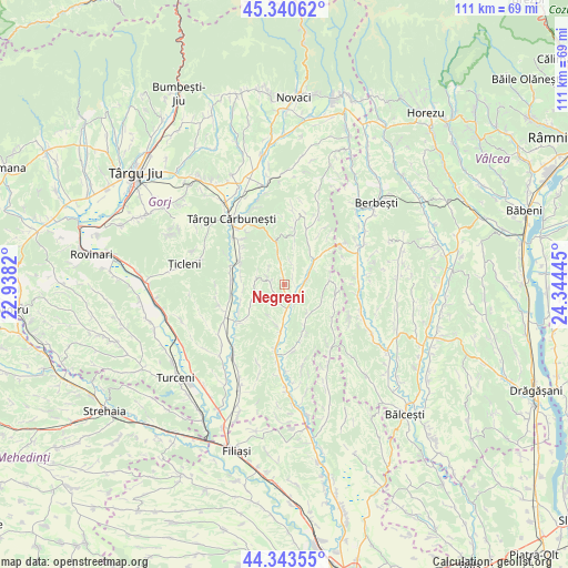
Negreni GPS coordinates[2]
44° 50' 39.264" North, 23° 38' 28.752" East
| Map corner | latitude | longitude |
|---|---|---|
| Upper-left | 45.34062°, | 22.9382° |
| Center: | 44.84424°, | 23.64132° |
| Lower-right: | 44.34355°, | 24.34445° |
| Map W x H: | 110.9×110.9 km | = 68.9×68.9mi |
| max Lat: | 48.23793° ⇑75.1% North |
| Negreni: | 44.84424° |
| min Lat: | ⇓24.9% South 43.65638° |
| min Long | Negreni | max Long |
| 20.31667° | 23.64132° | 29.65403° |
| W 25%⇐ | ⇒75% E |
Elevation
Elevation of Negreni is 246 m = 807 ft, and this is 8.9 m = 29 ft below average elevation for this country.
| Max E: |
1278 m = 4193 ft | 43.3% |
| Avg. | 254.9 m = 836 ft | |
| Negreni | 246 m = 807 ft | |
Min E: |
-2 m = -7 ft | 56.7% |
See also: Romania elevation on elevation.city.
Geographical zone
Negreni is located in North temperate zone (between Tropic of Cancer and the Arctic Circle). Distance of this Northern Tropic circle is 2380.3 km =1479 mi to South.| Distance of | km | miles | from Negreni |
|---|---|---|---|
| North Pole | 5020.8 | 3119.8 | to North |
| Arctic Circle | 2415 | 1500.6 | to North |
| Tropic Cancer | 2380.3 | 1479 | to South |
| Equator | 4986.2 | 3098.3 | to South |


Nearby cities:
15 places around Negreni: (largest is in red/bold)
• Andreești
9.4 km =5.8 mi,  229°
229°
• Berleşti
8.3 km =5.2 mi,  13°
13°
• Frasin
9.1 km =5.7 mi,  250°
250°
• Hurezani
5 km =3.1 mi,  172°
172°
• Licurici
8.3 km =5.2 mi,  346°
346°
• Logreşti
7.7 km =4.8 mi,  36°
36°
• Logrești Moșteni
8.6 km =5.3 mi, 35°
• Obârșia
10.3 km =6.4 mi,  107°
107°
• Petrești
10.5 km =6.5 mi,  273°
273°
• Piscoiu
8.9 km =5.5 mi,  84°
84°
• Stejari
9.2 km =5.7 mi,  158°
158°
• Totea
2.6 km =1.6 mi,  290°
290°
• Valea Deșului
5.7 km =3.5 mi,  282°
282°
• Vierșani
9.5 km =5.9 mi, 293°
• Vladimir
6 km =3.7 mi,  258°
258°
Sources, notices
• [Note1] Compared only with cities in Romania existing in our database
• [Src1] Map data: © OpenStreetMap contributors (CC-BY-SA)
• [Src2] Other city data from geonames.org with taken over terms of usage.
• [Src3] Geographical zone / Annual Mean Temperature by Robert A. Rohde @ Wikipedia
