Hurezani geodata
Hurezani (Gorj) is a seat of a second-order administrative division; located in Romania in Europe/Bucharest (GMT+3) time zone. With population of 1,826 people, there are 2792 cities with bigger population in this country. Compared to other cities in Romania, 76.8% of cities are located further ↑North; 74.9% of cities are located further →East and 52.9% of cities have lower elevation than Hurezani. Note1


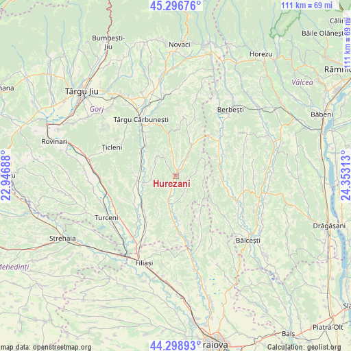
Hurezani GPS coordinates[2]
44° 48' 0" North, 23° 39' 0" East
| Map corner | latitude | longitude |
|---|---|---|
| Upper-left | 45.29676°, | 22.94688° |
| Center: | 44.8°, | 23.65° |
| Lower-right: | 44.29893°, | 24.35313° |
| Map W x H: | 110.9×110.9 km | = 68.9×68.9mi |
| max Lat: | 48.23793° ⇑76.8% North |
| Hurezani: | 44.8° |
| min Lat: | ⇓23.2% South 43.65638° |
| min Long | Hurezani | max Long |
| 20.31667° | 23.65° | 29.65403° |
| W 25.1%⇐ | ⇒74.9% E |
Elevation
Elevation of Hurezani is 227 m = 745 ft, and this is 27.9 m = 92 ft below average elevation for this country.
| Max E: |
1278 m = 4193 ft | 47.1% |
| Avg. | 254.9 m = 836 ft | |
| Hurezani | 227 m = 745 ft | |
Min E: |
-2 m = -7 ft | 52.9% |
See also: Romania elevation on elevation.city.
Geographical zone
Hurezani is located in North temperate zone (between Tropic of Cancer and the Arctic Circle). Distance of this Northern Tropic circle is 2375.4 km =1476 mi to South.| Distance of | km | miles | from Hurezani |
|---|---|---|---|
| North Pole | 5025.8 | 3122.9 | to North |
| Arctic Circle | 2419.9 | 1503.7 | to North |
| Tropic Cancer | 2375.4 | 1476 | to South |
| Equator | 4981.3 | 3095.2 | to South |


Nearby cities:
15 places around Hurezani: (largest is in red/bold)
• Andreești
7.9 km =4.9 mi,  261°
261°
• Baloșani
7.7 km =4.8 mi,  174°
174°
• Căpreni
6.2 km =3.9 mi,  205°
205°
• Dănciuleşti
10.8 km =6.7 mi,  133°
133°
• Frasin
9.4 km =5.8 mi,  281°
281°
• Logreşti
11.8 km =7.3 mi,  19°
19°
• Negreni
5 km =3.1 mi,  352°
352°
• Obârșia
9.4 km =5.8 mi,  78°
78°
• Piscoiu
10 km =6.2 mi,  54°
54°
• Rădinești
9.1 km =5.7 mi,  95°
95°
• Slăvuța
11.5 km =7.1 mi, 166°
• Stejari
4.5 km =2.8 mi,  144°
144°
• Totea
6.6 km =4.1 mi,  331°
331°
• Valea Deșului
8.8 km =5.5 mi,  314°
314°
• Vladimir
7.5 km =4.7 mi,  299°
299°
Sources, notices
• [Note1] Compared only with cities in Romania existing in our database
• [Src1] Map data: © OpenStreetMap contributors (CC-BY-SA)
• [Src2] Other city data from geonames.org with taken over terms of usage.
• [Src3] Geographical zone / Annual Mean Temperature by Robert A. Rohde @ Wikipedia
