Almăj geodata
Almăj (Dolj) is a seat of a second-order administrative division; located in Romania in Europe/Bucharest (GMT+3) time zone. With population of 529 people, there are 6783 cities with bigger population in this country. Compared to other cities in Romania, 86.8% of cities are located further ↑North; 74.1% of cities are located further →East and 54.6% of cities have higher elevation than Almăj. Note1


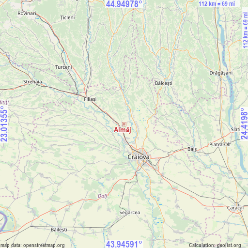
Almăj GPS coordinates[2]
44° 27' 0" North, 23° 43' 0.012" East
| Map corner | latitude | longitude |
|---|---|---|
| Upper-left | 44.94978°, | 23.01355° |
| Center: | 44.45°, | 23.71667° |
| Lower-right: | 43.94591°, | 24.4198° |
| Map W x H: | 111.6×111.6 km | = 69.3×69.3mi |
| max Lat: | 48.23793° ⇑86.8% North |
| Almăj: | 44.45° |
| min Lat: | ⇓13.2% South 43.65638° |
| min Long | Almăj | max Long |
| 20.31667° | 23.71667° | 29.65403° |
| W 25.9%⇐ | ⇒74.1% E |
Elevation
Elevation of Almăj is 189 m = 620 ft, and this is 65.9 m = 216 ft below average elevation for this country.
| Max E: |
1278 m = 4193 ft | 54.6% |
| Avg. | 254.9 m = 836 ft | |
| Almăj | 189 m = 620 ft | |
Min E: |
-2 m = -7 ft | 45.4% |
See also: Romania elevation on elevation.city.
Geographical zone
Almăj is located in North temperate zone (between Tropic of Cancer and the Arctic Circle). Distance of this Northern Tropic circle is 2336.5 km =1451.8 mi to South.| Distance of | km | miles | from Almăj |
|---|---|---|---|
| North Pole | 5064.7 | 3147.1 | to North |
| Arctic Circle | 2458.8 | 1527.8 | to North |
| Tropic Cancer | 2336.5 | 1451.8 | to South |
| Equator | 4942.4 | 3071.1 | to South |


Nearby cities:
15 places around Almăj: (largest is in red/bold)
• Albești
9.3 km =5.8 mi,  154°
154°
• Bogea
1.9 km =1.2 mi,  205°
205°
• Brădeşti
7.6 km =4.7 mi,  299°
299°
• Cornetu
6.1 km =3.8 mi,  99°
99°
• Coţofenii din Dos
8.2 km =5.1 mi,  256°
256°
• Coțofenii din Față
4.9 km =3 mi,  282°
282°
• Goiești
5.4 km =3.4 mi,  46°
46°
• Işalniţa
5.7 km =3.5 mi,  166°
166°
• Mihăița
7.6 km =4.7 mi, 212°
• Milești
5.5 km =3.4 mi,  89°
89°
• Mălăești
2.4 km =1.5 mi, 53°
• Negoiești
9.6 km =6 mi,  4°
4°
• Potmelțu
6.8 km =4.2 mi,  229°
229°
• Şimnicu de Sus
9.9 km =6.2 mi,  138°
138°
• Șitoaia
3.1 km =1.9 mi, 171°
Sources, notices
• [Note1] Compared only with cities in Romania existing in our database
• [Src1] Map data: © OpenStreetMap contributors (CC-BY-SA)
• [Src2] Other city data from geonames.org with taken over terms of usage.
• [Src3] Geographical zone / Annual Mean Temperature by Robert A. Rohde @ Wikipedia
