Potmelțu geodata
Potmelțu (Dolj) is a populated place; located in Romania in Europe/Bucharest (GMT+3) time zone. With population of 543 people, there are 6655 cities with bigger population in this country. Compared to other cities in Romania, 87.9% of cities are located further ↑North; 74.8% of cities are located further →East and 81.9% of cities have higher elevation than Potmelțu. Note1


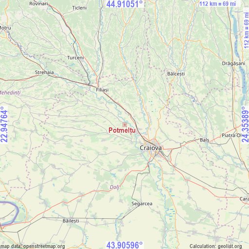
Potmelțu GPS coordinates[2]
44° 24' 37.404" North, 23° 39' 2.736" East
| Map corner | latitude | longitude |
|---|---|---|
| Upper-left | 44.91051°, | 22.94764° |
| Center: | 44.41039°, | 23.65076° |
| Lower-right: | 43.90596°, | 24.35389° |
| Map W x H: | 111.7×111.7 km | = 69.4×69.4mi |
| max Lat: | 48.23793° ⇑87.9% North |
| Potmelțu: | 44.41039° |
| min Lat: | ⇓12.1% South 43.65638° |
| min Long | Potmelțu | max Long |
| 20.31667° | 23.65076° | 29.65403° |
| W 25.2%⇐ | ⇒74.8% E |
Elevation
Elevation of Potmelțu is 88 m = 289 ft, and this is 166.9 m = 548 ft below average elevation for this country.
| Max E: |
1278 m = 4193 ft | 81.9% |
| Avg. | 254.9 m = 836 ft | |
| Potmelțu | 88 m = 289 ft | |
Min E: |
-2 m = -7 ft | 18.1% |
See also: Romania elevation on elevation.city.
Geographical zone
Potmelțu is located in North temperate zone (between Tropic of Cancer and the Arctic Circle). Distance of this Northern Tropic circle is 2332.1 km =1449.1 mi to South.| Distance of | km | miles | from Potmelțu |
|---|---|---|---|
| North Pole | 5069.1 | 3149.8 | to North |
| Arctic Circle | 2463.2 | 1530.6 | to North |
| Tropic Cancer | 2332.1 | 1449.1 | to South |
| Equator | 4938 | 3068.3 | to South |


Nearby cities:
15 places around Potmelțu: (largest is in red/bold)
• Albești
10.1 km =6.3 mi,  113°
113°
• Almăj
6.8 km =4.2 mi,  49°
49°
• Bogea
5.1 km =3.2 mi,  59°
59°
• Breasta
9 km =5.6 mi,  163°
163°
• Brădeşti
8.2 km =5.1 mi,  350°
350°
• Coţofenii din Dos
3.7 km =2.3 mi,  313°
313°
• Coțofenii din Față
5.5 km =3.4 mi,  5°
5°
• Işalniţa
6.7 km =4.2 mi,  99°
99°
• Mihăița
2.3 km =1.4 mi,  150°
150°
• Mălăești
9.3 km =5.8 mi, 50°
• Predeşti
7.8 km =4.8 mi,  210°
210°
• Rovine
7.8 km =4.8 mi,  134°
134°
• Scăeşti
8.2 km =5.1 mi,  319°
319°
• Valea Lungului
6.7 km =4.2 mi,  168°
168°
• Șitoaia
5.8 km =3.6 mi,  76°
76°
Sources, notices
• [Note1] Compared only with cities in Romania existing in our database
• [Src1] Map data: © OpenStreetMap contributors (CC-BY-SA)
• [Src2] Other city data from geonames.org with taken over terms of usage.
• [Src3] Geographical zone / Annual Mean Temperature by Robert A. Rohde @ Wikipedia
