Aleşd geodata
Aleşd (Bihor) is a seat of a second-order administrative division; located in Romania in Europe/Bucharest (GMT+3) time zone. With population of 10,264 people, there are 205 cities with bigger population in this country. Compared to other cities in Romania, 80.6% of cities are located further ↓South; 90.5% of cities are located further →East and 58.6% of cities have lower elevation than Aleşd. Note1


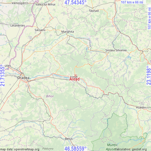
Aleşd GPS coordinates[2]
47° 4' 0.012" North, 22° 25' 0.012" East
| Map corner | latitude | longitude |
|---|---|---|
| Upper-left | 47.54345°, | 21.71355° |
| Center: | 47.06667°, | 22.41667° |
| Lower-right: | 46.58559°, | 23.1198° |
| Map W x H: | 106.5×106.5 km | = 66.2×66.2mi |
| max Lat: | 48.23793° ⇑19.4% North |
| Aleşd: | 47.06667° |
| min Lat: | ⇓80.6% South 43.65638° |
| min Long | Aleşd | max Long |
| 20.31667° | 22.41667° | 29.65403° |
| W 9.5%⇐ | ⇒90.5% E |
Elevation
Elevation of Aleşd is 255 m = 837 ft, and this is 0.099999999999994 m = 0 ft above average elevation for this country.
| Max E: |
1278 m = 4193 ft | 41.4% |
| Aleşd | 255 m 837 ft | |
| Avg. | 254.9 m = 836 ft | |
Min E: |
-2 m = -7 ft | 58.6% |
See also: Romania elevation on elevation.city.
Geographical zone
Aleşd is located in North temperate zone (between Tropic of Cancer and the Arctic Circle). Distance of this North polar circle is 2167.9 km =1347.1 mi to North.| Distance of | km | miles | from Aleşd |
|---|---|---|---|
| North Pole | 4773.7 | 2966.2 | to North |
| Arctic Circle | 2167.9 | 1347.1 | to North |
| Tropic Cancer | 2627.4 | 1632.6 | to South |
| Equator | 5233.3 | 3251.8 | to South |


Nearby cities:
15 places around Aleşd: (largest is in red/bold)
• Auşeu
7.3 km =4.5 mi,  120°
120°
• Aştileu
4.5 km =2.8 mi,  214°
214°
• Chistag
5.1 km =3.2 mi,  243°
243°
• Călățea
8.8 km =5.5 mi,  183°
183°
• Dobricionești
9.2 km =5.7 mi,  149°
149°
• Groși
5.3 km =3.3 mi, 116°
• Lugaşu de Jos
5 km =3.1 mi,  270°
270°
• Lugașu de Sus
4.8 km =3 mi,  286°
286°
• Luncșoara
10.1 km =6.3 mi,  109°
109°
• Măgeşti
6.1 km =3.8 mi,  155°
155°
• Peștere
5.4 km =3.4 mi, 212°
• Peștiș
0.7 km =0.4 mi,  332°
332°
• Subpiatră
9.5 km =5.9 mi, 241°
• Tinăud
2 km =1.2 mi,  140°
140°
• Țețchea
7.3 km =4.5 mi,  251°
251°
Sources, notices
• [Note1] Compared only with cities in Romania existing in our database
• [Src1] Map data: © OpenStreetMap contributors (CC-BY-SA)
• [Src2] Other city data from geonames.org with taken over terms of usage.
• [Src3] Geographical zone / Annual Mean Temperature by Robert A. Rohde @ Wikipedia
