Subpiatră geodata
Subpiatră (Bihor) is a populated place; located in Romania in Europe/Bucharest (GMT+3) time zone. With population of 640 people, there are 5938 cities with bigger population in this country. Compared to other cities in Romania, 79.6% of cities are located further ↓South; 91.6% of cities are located further →East and 56.2% of cities have lower elevation than Subpiatră. Note1


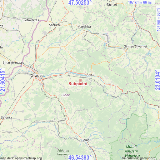
Subpiatră GPS coordinates[2]
47° 1' 31.368" North, 22° 18' 26.172" East
| Map corner | latitude | longitude |
|---|---|---|
| Upper-left | 47.50253°, | 21.60415° |
| Center: | 47.02538°, | 22.30727° |
| Lower-right: | 46.54393°, | 23.0104° |
| Map W x H: | 106.6×106.6 km | = 66.2×66.2mi |
| max Lat: | 48.23793° ⇑20.4% North |
| Subpiatră: | 47.02538° |
| min Lat: | ⇓79.6% South 43.65638° |
| min Long | Subpiatră | max Long |
| 20.31667° | 22.30727° | 29.65403° |
| W 8.4%⇐ | ⇒91.6% E |
Elevation
Elevation of Subpiatră is 244 m = 801 ft, and this is 10.9 m = 36 ft below average elevation for this country.
| Max E: |
1278 m = 4193 ft | 43.8% |
| Avg. | 254.9 m = 836 ft | |
| Subpiatră | 244 m = 801 ft | |
Min E: |
-2 m = -7 ft | 56.2% |
See also: Romania elevation on elevation.city.
Geographical zone
Subpiatră is located in North temperate zone (between Tropic of Cancer and the Arctic Circle). Distance of this North polar circle is 2172.4 km =1349.9 mi to North.| Distance of | km | miles | from Subpiatră |
|---|---|---|---|
| North Pole | 4778.3 | 2969.1 | to North |
| Arctic Circle | 2172.4 | 1349.9 | to North |
| Tropic Cancer | 2622.8 | 1629.7 | to South |
| Equator | 5228.7 | 3249 | to South |


Nearby cities:
15 places around Subpiatră: (largest is in red/bold)
• Aştileu
5.8 km =3.6 mi,  81°
81°
• Chistag
4.4 km =2.7 mi,  57°
57°
• Călățea
8.8 km =5.5 mi,  118°
118°
• Hotar
1.8 km =1.1 mi,  249°
249°
• Lugaşu de Jos
5.6 km =3.5 mi,  35°
35°
• Lugașu de Sus
7 km =4.3 mi,  31°
31°
• Peștere
5.4 km =3.4 mi,  89°
89°
• Telechiu
4.2 km =2.6 mi,  323°
323°
• Tileagd
9.3 km =5.8 mi,  299°
299°
• Tilecuș
6.7 km =4.2 mi,  267°
267°
• Uileacu de Criș
9.4 km =5.8 mi,  311°
311°
• Urvind
5 km =3.1 mi,  339°
339°
• Vârciorog
6.6 km =4.1 mi,  184°
184°
• Șerghiș
7.1 km =4.4 mi,  225°
225°
• Țețchea
2.6 km =1.6 mi, 30°
Sources, notices
• [Note1] Compared only with cities in Romania existing in our database
• [Src1] Map data: © OpenStreetMap contributors (CC-BY-SA)
• [Src2] Other city data from geonames.org with taken over terms of usage.
• [Src3] Geographical zone / Annual Mean Temperature by Robert A. Rohde @ Wikipedia
