Chistag geodata
Chistag (Bihor) is a populated place; located in Romania in Europe/Bucharest (GMT+3) time zone. With population of 660 people, there are 5817 cities with bigger population in this country. Compared to other cities in Romania, 80.1% of cities are located further ↓South; 91.1% of cities are located further →East and 50.5% of cities have lower elevation than Chistag. Note1


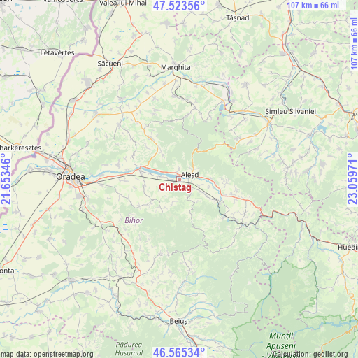
Chistag GPS coordinates[2]
47° 2' 47.76" North, 22° 21' 23.688" East
| Map corner | latitude | longitude |
|---|---|---|
| Upper-left | 47.52356°, | 21.65346° |
| Center: | 47.0466°, | 22.35658° |
| Lower-right: | 46.56534°, | 23.05971° |
| Map W x H: | 106.5×106.5 km | = 66.2×66.2mi |
| max Lat: | 48.23793° ⇑19.9% North |
| Chistag: | 47.0466° |
| min Lat: | ⇓80.1% South 43.65638° |
| min Long | Chistag | max Long |
| 20.31667° | 22.35658° | 29.65403° |
| W 8.9%⇐ | ⇒91.1% E |
Elevation
Elevation of Chistag is 214 m = 702 ft, and this is 40.9 m = 134 ft below average elevation for this country.
| Max E: |
1278 m = 4193 ft | 49.5% |
| Avg. | 254.9 m = 836 ft | |
| Chistag | 214 m = 702 ft | |
Min E: |
-2 m = -7 ft | 50.5% |
See also: Romania elevation on elevation.city.
Geographical zone
Chistag is located in North temperate zone (between Tropic of Cancer and the Arctic Circle). Distance of this North polar circle is 2170.1 km =1348.4 mi to North.| Distance of | km | miles | from Chistag |
|---|---|---|---|
| North Pole | 4776 | 2967.7 | to North |
| Arctic Circle | 2170.1 | 1348.4 | to North |
| Tropic Cancer | 2625.2 | 1631.2 | to South |
| Equator | 5231.1 | 3250.5 | to South |


Nearby cities:
15 places around Chistag: (largest is in red/bold)
• Aleşd
5.1 km =3.2 mi,  63°
63°
• Aştileu
2.5 km =1.6 mi,  126°
126°
• Cuieșd
8.6 km =5.3 mi,  327°
327°
• Călățea
7.7 km =4.8 mi,  148°
148°
• Hotar
6.2 km =3.9 mi,  241°
241°
• Lugaşu de Jos
2.3 km =1.4 mi,  347°
347°
• Lugașu de Sus
3.6 km =2.2 mi,  359°
359°
• Măgeşti
7.8 km =4.8 mi,  115°
115°
• Peștere
2.9 km =1.8 mi,  143°
143°
• Peștiș
5.1 km =3.2 mi, 55°
• Subpiatră
4.4 km =2.7 mi, 237°
• Telechiu
6.3 km =3.9 mi,  278°
278°
• Tinăud
5.9 km =3.7 mi,  83°
83°
• Urvind
6 km =3.7 mi,  292°
292°
• Țețchea
2.4 km =1.5 mi,  268°
268°
Sources, notices
• [Note1] Compared only with cities in Romania existing in our database
• [Src1] Map data: © OpenStreetMap contributors (CC-BY-SA)
• [Src2] Other city data from geonames.org with taken over terms of usage.
• [Src3] Geographical zone / Annual Mean Temperature by Robert A. Rohde @ Wikipedia
