Platičevo geodata
Platičevo (Vojvodina) is a populated place; located in Serbia in Europe/Belgrade (GMT+2) time zone. With population of 2,812 people, there are 159 cities with bigger population in this country. Compared to other cities in Serbia, 51.2% of cities are located further ↑North; 73.7% of cities are located further →East and 78.9% of cities have higher elevation than Platičevo. Note1


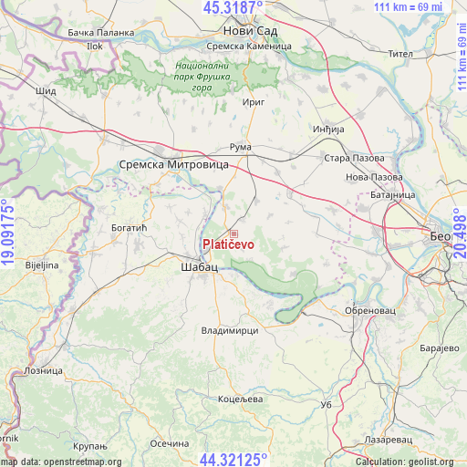
Platičevo GPS coordinates[2]
44° 49' 19.668" North, 19° 47' 41.532" East
| Map corner | latitude | longitude |
|---|---|---|
| Upper-left | 45.3187°, | 19.09175° |
| Center: | 44.82213°, | 19.79487° |
| Lower-right: | 44.32125°, | 20.498° |
| Map W x H: | 110.9×110.9 km | = 68.9×68.9mi |
| max Lat: | 46.1° ⇑51.2% North |
| Platičevo: | 44.82213° |
| min Lat: | ⇓48.8% South 42.25846° |
| min Long | Platičevo | max Long |
| 18.9276° | 19.79487° | 22.77556° |
| W 26.3%⇐ | ⇒73.7% E |
Elevation
Elevation of Platičevo is 78 m = 256 ft, and this is 98.4 m = 323 ft below average elevation for this country.
| Max E: |
1421 m = 4662 ft | 78.9% |
| Avg. | 176.4 m = 579 ft | |
| Platičevo | 78 m = 256 ft | |
Min E: |
49 m = 161 ft | 21.1% |
See also: Serbia elevation on elevation.city.
Geographical zone
Platičevo is located in North temperate zone (between Tropic of Cancer and the Arctic Circle). Distance of this Northern Tropic circle is 2377.8 km =1477.5 mi to South.| Distance of | km | miles | from Platičevo |
|---|---|---|---|
| North Pole | 5023.3 | 3121.3 | to North |
| Arctic Circle | 2417.4 | 1502.1 | to North |
| Tropic Cancer | 2377.8 | 1477.5 | to South |
| Equator | 4983.8 | 3096.8 | to South |


Nearby cities:
15 places around Platičevo: (largest is in red/bold)
• Buđanovci
9.6 km =6 mi,  34°
34°
• Drenovac
8.3 km =5.2 mi,  306°
306°
• Grabovci
7.5 km =4.7 mi,  148°
148°
• Hrtkovci
7 km =4.3 mi,  339°
339°
• Jarak
11.2 km =7 mi, 343°
• Jelenča
11.6 km =7.2 mi,  204°
204°
• Jevremovac
15.2 km =9.4 mi,  222°
222°
• Klenak
7.7 km =4.8 mi,  240°
240°
• Majur
12.4 km =7.7 mi, 242°
• Nikinci
3.8 km =2.4 mi,  35°
35°
• Pocerski Pričinović
13.1 km =8.1 mi,  211°
211°
• Tabanović
12.1 km =7.5 mi,  268°
268°
• Šabac
11.8 km =7.3 mi, 224°
• Ševarice
11.7 km =7.3 mi,  295°
295°
• Štitar
16 km =9.9 mi,  258°
258°
Sources, notices
• [Note1] Compared only with cities in Serbia existing in our database
• [Src1] Map data: © OpenStreetMap contributors (CC-BY-SA)
• [Src2] Other city data from geonames.org with taken over terms of usage.
• [Src3] Geographical zone / Annual Mean Temperature by Robert A. Rohde @ Wikipedia
