Bački Petrovac geodata
Bački Petrovac (Vojvodina) is a seat of a third-order administrative division; located in Serbia in Europe/Belgrade (GMT+2) time zone. With population of 7,229 people, there are 68 cities with bigger population in this country. Compared to other cities in Serbia, 79.4% of cities are located further ↓South; 83.4% of cities are located further →East and 58.5% of cities have higher elevation than Bački Petrovac. Note1


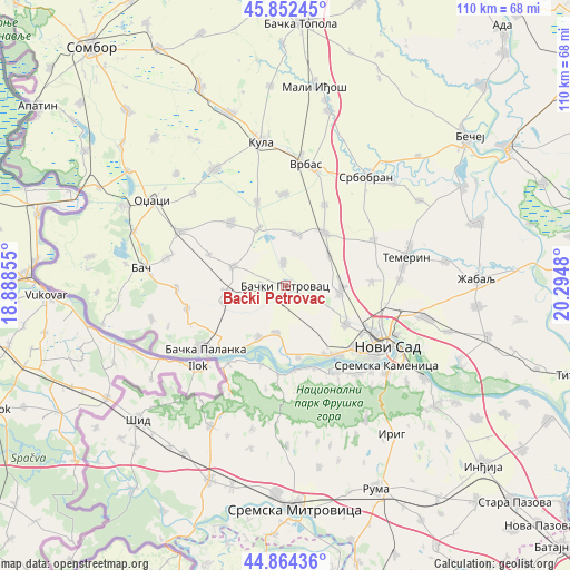
Bački Petrovac GPS coordinates[2]
45° 21' 38.016" North, 19° 35' 30.012" East
| Map corner | latitude | longitude |
|---|---|---|
| Upper-left | 45.85245°, | 18.88855° |
| Center: | 45.36056°, | 19.59167° |
| Lower-right: | 44.86436°, | 20.2948° |
| Map W x H: | 109.9×109.9 km | = 68.3×68.3mi |
| max Lat: | 46.1° ⇑20.6% North |
| Bački Petrovac: | 45.36056° |
| min Lat: | ⇓79.4% South 42.25846° |
| min Long | Bački Petrovac | max Long |
| 18.9276° | 19.59167° | 22.77556° |
| W 16.6%⇐ | ⇒83.4% E |
Elevation
Elevation of Bački Petrovac is 83 m = 272 ft, and this is 93.4 m = 306 ft below average elevation for this country.
| Max E: |
1421 m = 4662 ft | 58.5% |
| Avg. | 176.4 m = 579 ft | |
| Bački Petrovac | 83 m = 272 ft | |
Min E: |
49 m = 161 ft | 41.5% |
See also: Serbia elevation on elevation.city.
Geographical zone
Bački Petrovac is located in North temperate zone (between Tropic of Cancer and the Arctic Circle). Distance of this North polar circle is 2357.6 km =1464.9 mi to North.| Distance of | km | miles | from Bački Petrovac |
|---|---|---|---|
| North Pole | 4963.4 | 3084.1 | to North |
| Arctic Circle | 2357.6 | 1464.9 | to North |
| Tropic Cancer | 2437.7 | 1514.7 | to South |
| Equator | 5043.6 | 3133.9 | to South |


Nearby cities:
15 places around Bački Petrovac: (largest is in red/bold)
• Bačka Palanka
19.6 km =12.2 mi,  231°
231°
• Beočin
19.7 km =12.2 mi,  149°
149°
• Despotovo
12.2 km =7.6 mi,  335°
335°
• Gložan
9.2 km =5.7 mi,  191°
191°
• Kisač
10.8 km =6.7 mi,  93°
93°
• Kulpin
4.7 km =2.9 mi,  356°
356°
• Maglić
4.7 km =2.9 mi,  272°
272°
• Novi Sad
22.7 km =14.1 mi,  122°
122°
• Obrovac
19.4 km =12.1 mi,  256°
256°
• Ravno Selo
10.2 km =6.3 mi,  12°
12°
• Rumenka
14 km =8.7 mi, 122°
• Stepanovićevo
10.3 km =6.4 mi,  55°
55°
• Veternik
17.6 km =10.9 mi,  132°
132°
• Zmajevo
12.9 km =8 mi,  36°
36°
• Čelarevo
11.3 km =7 mi,  207°
207°
Sources, notices
• [Note1] Compared only with cities in Serbia existing in our database
• [Src1] Map data: © OpenStreetMap contributors (CC-BY-SA)
• [Src2] Other city data from geonames.org with taken over terms of usage.
• [Src3] Geographical zone / Annual Mean Temperature by Robert A. Rohde @ Wikipedia
