Maglić geodata
Maglić (Vojvodina) is a populated place; located in Serbia in Europe/Belgrade (GMT+2) time zone. With population of 2,733 people, there are 163 cities with bigger population in this country. Compared to other cities in Serbia, 79.6% of cities are located further ↓South; 86.4% of cities are located further →East and 58.5% of cities have higher elevation than Maglić. Note1


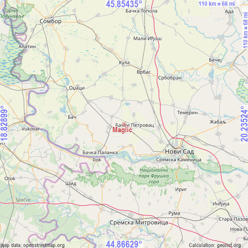
Maglić GPS coordinates[2]
45° 21' 44.928" North, 19° 31' 55.596" East
| Map corner | latitude | longitude |
|---|---|---|
| Upper-left | 45.85435°, | 18.82899° |
| Center: | 45.36248°, | 19.53211° |
| Lower-right: | 44.86629°, | 20.23524° |
| Map W x H: | 109.9×109.9 km | = 68.3×68.3mi |
| max Lat: | 46.1° ⇑20.4% North |
| Maglić: | 45.36248° |
| min Lat: | ⇓79.6% South 42.25846° |
| min Long | Maglić | max Long |
| 18.9276° | 19.53211° | 22.77556° |
| W 13.6%⇐ | ⇒86.4% E |
Elevation
Elevation of Maglić is 83 m = 272 ft, and this is 93.4 m = 306 ft below average elevation for this country.
| Max E: |
1421 m = 4662 ft | 58.5% |
| Avg. | 176.4 m = 579 ft | |
| Maglić | 83 m = 272 ft | |
Min E: |
49 m = 161 ft | 41.5% |
See also: Serbia elevation on elevation.city.
Geographical zone
Maglić is located in North temperate zone (between Tropic of Cancer and the Arctic Circle). Distance of this North polar circle is 2357.3 km =1464.8 mi to North.| Distance of | km | miles | from Maglić |
|---|---|---|---|
| North Pole | 4963.2 | 3084 | to North |
| Arctic Circle | 2357.3 | 1464.8 | to North |
| Tropic Cancer | 2437.9 | 1514.8 | to South |
| Equator | 5043.8 | 3134.1 | to South |


Nearby cities:
15 places around Maglić: (largest is in red/bold)
• Bač
23.3 km =14.5 mi,  278°
278°
• Bačka Palanka
16.4 km =10.2 mi,  220°
220°
• Bački Petrovac
4.7 km =2.9 mi,  92°
92°
• Beočin
22.6 km =14 mi,  139°
139°
• Despotovo
10.8 km =6.7 mi,  357°
357°
• Gložan
9.6 km =6 mi,  162°
162°
• Kisač
15.5 km =9.6 mi, 93°
• Kulpin
6.2 km =3.9 mi,  44°
44°
• Obrovac
14.9 km =9.3 mi,  252°
252°
• Ravno Selo
11.9 km =7.4 mi, 35°
• Rumenka
18.2 km =11.3 mi,  114°
114°
• Stepanovićevo
14.3 km =8.9 mi,  66°
66°
• Veternik
21.4 km =13.3 mi,  124°
124°
• Zmajevo
16 km =9.9 mi,  50°
50°
• Čelarevo
10.3 km =6.4 mi,  183°
183°
Sources, notices
• [Note1] Compared only with cities in Serbia existing in our database
• [Src1] Map data: © OpenStreetMap contributors (CC-BY-SA)
• [Src2] Other city data from geonames.org with taken over terms of usage.
• [Src3] Geographical zone / Annual Mean Temperature by Robert A. Rohde @ Wikipedia
