Rakovica geodata
Rakovica (Central Serbia) is a seat of a third-order administrative division; located in Serbia in Europe/Belgrade (GMT+2) time zone. In our database, there are 365 cities with bigger population. Compared to other cities in Serbia, 56.9% of cities are located further ↑North; 54.4% of cities are located further ←West and 55.3% of cities have lower elevation than Rakovica. Note1
Administrative division(s):
- Level 1: Central Serbia
- Level 2: Belgrade
- Level 3: Opština Beograd-Rakovica


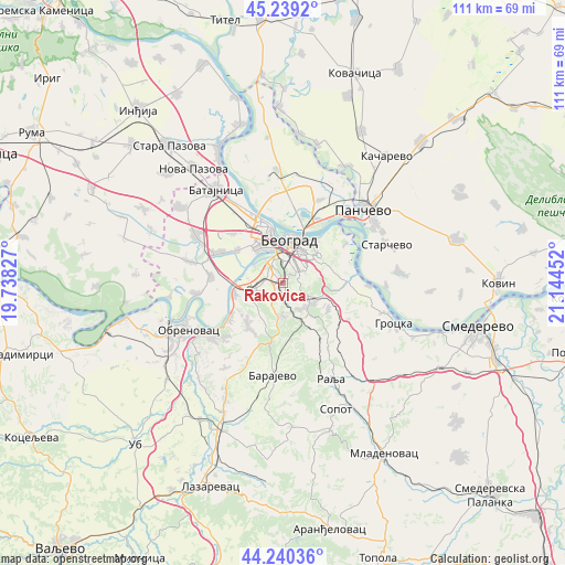
Rakovica GPS coordinates[2]
44° 44' 30.984" North, 20° 26' 29.004" East
| Map corner | latitude | longitude |
|---|---|---|
| Upper-left | 45.2392°, | 19.73827° |
| Center: | 44.74194°, | 20.44139° |
| Lower-right: | 44.24036°, | 21.14452° |
| Map W x H: | 111.1×111.1 km | = 69×69mi |
| max Lat: | 46.1° ⇑56.9% North |
| Rakovica: | 44.74194° |
| min Lat: | ⇓43.1% South 42.25846° |
| min Long | Rakovica | max Long |
| 18.9276° | 20.44139° | 22.77556° |
| W 54.4%⇐ | ⇒45.6% E |
Elevation
Elevation of Rakovica is 98 m = 322 ft, and this is 78.4 m = 257 ft below average elevation for this country.
| Max E: |
1421 m = 4662 ft | 44.7% |
| Avg. | 176.4 m = 579 ft | |
| Rakovica | 98 m = 322 ft | |
Min E: |
49 m = 161 ft | 55.3% |
See also: Serbia elevation on elevation.city.
Geographical zone
Rakovica is located in North temperate zone (between Tropic of Cancer and the Arctic Circle). Distance of this Northern Tropic circle is 2368.9 km =1472 mi to South.| Distance of | km | miles | from Rakovica |
|---|---|---|---|
| North Pole | 5032.2 | 3126.9 | to North |
| Arctic Circle | 2426.3 | 1507.6 | to North |
| Tropic Cancer | 2368.9 | 1472 | to South |
| Equator | 4974.8 | 3091.2 | to South |


Nearby cities:
15 places around Rakovica: (largest is in red/bold)
• Belgrade
7.2 km =4.5 mi,  15°
15°
• Novi Beograd
7.2 km =4.5 mi,  349°
349°
• Ostružnica
9.8 km =6.1 mi,  260°
260°
• Palilula
9.7 km =6 mi,  37°
37°
• Rušanj
6.4 km =4 mi,  173°
173°
• Savski Venac
4.3 km =2.7 mi,  13°
13°
• Sremčica
8.2 km =5.1 mi,  208°
208°
• Stari Grad
8.6 km =5.3 mi, 10°
• Umka
12.9 km =8 mi,  236°
236°
• Velika Moštanica
11 km =6.8 mi,  218°
218°
• Voždovac
4.9 km =3 mi,  33°
33°
• Vračar
6.2 km =3.9 mi, 25°
• Zemun
12 km =7.5 mi,  344°
344°
• Zvezdara
8 km =5 mi,  63°
63°
• Čukarica
4.8 km =3 mi, 339°
Sources, notices
• [Note1] Compared only with cities in Serbia existing in our database
• [Src1] Map data: © OpenStreetMap contributors (CC-BY-SA)
• [Src2] Other city data from geonames.org with taken over terms of usage.
• [Src3] Geographical zone / Annual Mean Temperature by Robert A. Rohde @ Wikipedia
