Rušanj geodata
Rušanj (Central Serbia) is a populated place; located in Serbia in Europe/Belgrade (GMT+2) time zone. With population of 4,769 people, there are 97 cities with bigger population in this country. Compared to other cities in Serbia, 59.6% of cities are located further ↑North; 55.1% of cities are located further ←West and 76.4% of cities have lower elevation than Rušanj. Note1


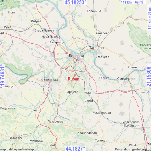
Rušanj GPS coordinates[2]
44° 41' 5.172" North, 20° 26' 59.748" East
| Map corner | latitude | longitude |
|---|---|---|
| Upper-left | 45.18253°, | 19.74681° |
| Center: | 44.68477°, | 20.44993° |
| Lower-right: | 44.1827°, | 21.15306° |
| Map W x H: | 111.2×111.2 km | = 69.1×69.1mi |
| max Lat: | 46.1° ⇑59.6% North |
| Rušanj: | 44.68477° |
| min Lat: | ⇓40.4% South 42.25846° |
| min Long | Rušanj | max Long |
| 18.9276° | 20.44993° | 22.77556° |
| W 55.1%⇐ | ⇒44.9% E |
Elevation
Elevation of Rušanj is 201 m = 659 ft, and this is 24.6 m = 81 ft above average elevation for this country.
| Max E: |
1421 m = 4662 ft | 23.6% |
| Rušanj | 201 m 659 ft | |
| Avg. | 176.4 m = 579 ft | |
Min E: |
49 m = 161 ft | 76.4% |
See also: Serbia elevation on elevation.city.
Geographical zone
Rušanj is located in North temperate zone (between Tropic of Cancer and the Arctic Circle). Distance of this Northern Tropic circle is 2362.6 km =1468.1 mi to South.| Distance of | km | miles | from Rušanj |
|---|---|---|---|
| North Pole | 5038.6 | 3130.8 | to North |
| Arctic Circle | 2432.7 | 1511.6 | to North |
| Tropic Cancer | 2362.6 | 1468.1 | to South |
| Equator | 4968.5 | 3087.3 | to South |


Nearby cities:
15 places around Rušanj: (largest is in red/bold)
• Barajevo
12.1 km =7.5 mi,  192°
192°
• Belgrade
13.3 km =8.3 mi,  5°
5°
• Mala Moštanica
12.5 km =7.8 mi,  245°
245°
• Novi Beograd
13.6 km =8.5 mi,  351°
351°
• Ostružnica
11.4 km =7.1 mi,  294°
294°
• Rakovica
6.4 km =4 mi, 353°
• Savski Venac
10.5 km =6.5 mi,  1°
1°
• Sremčica
4.6 km =2.9 mi,  258°
258°
• Umka
11.5 km =7.1 mi,  266°
266°
• Velika Moštanica
7.9 km =4.9 mi, 253°
• Voždovac
10.6 km =6.6 mi, 11°
• Vranić
13.3 km =8.3 mi,  226°
226°
• Vračar
12.1 km =7.5 mi, 9°
• Zvezdara
11.9 km =7.4 mi,  32°
32°
• Čukarica
11.1 km =6.9 mi, 347°
Sources, notices
• [Note1] Compared only with cities in Serbia existing in our database
• [Src1] Map data: © OpenStreetMap contributors (CC-BY-SA)
• [Src2] Other city data from geonames.org with taken over terms of usage.
• [Src3] Geographical zone / Annual Mean Temperature by Robert A. Rohde @ Wikipedia
