Miratovac geodata
Miratovac (Central Serbia) is a populated place; located in Serbia in Europe/Belgrade (GMT+2) time zone. With population of 2,872 people, there are 154 cities with bigger population in this country. Compared to other cities in Serbia, 100% of cities are located further ↑North; 88.2% of cities are located further ←West and 94.8% of cities have lower elevation than Miratovac. Note1


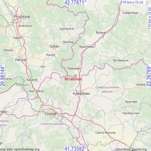
Miratovac GPS coordinates[2]
42° 15' 30.456" North, 21° 39' 52.416" East
| Map corner | latitude | longitude |
|---|---|---|
| Upper-left | 42.77671°, | 20.96144° |
| Center: | 42.25846°, | 21.66456° |
| Lower-right: | 41.73592°, | 22.36769° |
| Map W x H: | 115.7×115.7 km | = 71.9×71.9mi |
| max Lat: | 46.1° ⇑100% North |
| Miratovac: | 42.25846° |
| min Lat: | ⇓0% South 42.25846° |
| min Long | Miratovac | max Long |
| 18.9276° | 21.66456° | 22.77556° |
| W 88.2%⇐ | ⇒11.8% E |
Elevation
Elevation of Miratovac is 481 m = 1578 ft, and this is 304.6 m = 999 ft above average elevation for this country.
| Max E: |
1421 m = 4662 ft | 5.2% |
| Miratovac | 481 m 1578 ft | |
| Avg. | 176.4 m = 579 ft | |
Min E: |
49 m = 161 ft | 94.8% |
See also: Serbia elevation on elevation.city.
Geographical zone
Miratovac is located in North temperate zone (between Tropic of Cancer and the Arctic Circle). Distance of this Northern Tropic circle is 2092.8 km =1300.4 mi to South.| Distance of | km | miles | from Miratovac |
|---|---|---|---|
| North Pole | 5308.4 | 3298.5 | to North |
| Arctic Circle | 2702.5 | 1679.3 | to North |
| Tropic Cancer | 2092.8 | 1300.4 | to South |
| Equator | 4698.7 | 2919.6 | to South |


Nearby cities:
15 places around Miratovac: (largest is in red/bold)
• Biljača
12.7 km =7.9 mi,  32°
32°
• Bujanovac
23.8 km =14.8 mi,  20°
20°
• Buštranje
11 km =6.8 mi,  42°
42°
• Lagja e Korbajve
15.7 km =9.8 mi, 24°
• Lagja e Poshtme
15.4 km =9.6 mi, 20°
• Lagja e Shimshirve
14.9 km =9.3 mi, 24°
• Lagja e Ternovcalive
16 km =9.9 mi, 23°
• Preševo
5.8 km =3.6 mi,  347°
347°
• Rajince
13.6 km =8.5 mi,  10°
10°
• Samoljica
15.2 km =9.4 mi, 23°
• Spančevac
19.6 km =12.2 mi,  53°
53°
• Sumulicë
15.4 km =9.6 mi, 21°
• Trgovište
36.3 km =22.6 mi,  71°
71°
• Vranje
37.9 km =23.5 mi, 30°
• Žujince
7.1 km =4.4 mi, 25°
Sources, notices
• [Note1] Compared only with cities in Serbia existing in our database
• [Src1] Map data: © OpenStreetMap contributors (CC-BY-SA)
• [Src2] Other city data from geonames.org with taken over terms of usage.
• [Src3] Geographical zone / Annual Mean Temperature by Robert A. Rohde @ Wikipedia
