Boka geodata
Boka (Vojvodina) is a populated place; located in Serbia in Europe/Belgrade (GMT+2) time zone. With population of 2,246 people, there are 194 cities with bigger population in this country. Compared to other cities in Serbia, 79.1% of cities are located further ↓South; 70.5% of cities are located further ←West and 94.6% of cities have higher elevation than Boka. Note1


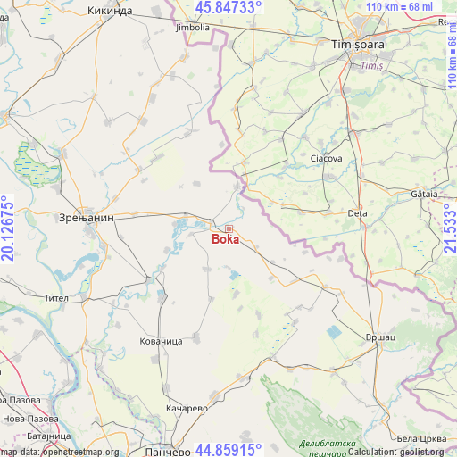
Boka GPS coordinates[2]
45° 21' 19.44" North, 20° 49' 47.532" East
| Map corner | latitude | longitude |
|---|---|---|
| Upper-left | 45.84733°, | 20.12675° |
| Center: | 45.3554°, | 20.82987° |
| Lower-right: | 44.85915°, | 21.533° |
| Map W x H: | 109.9×109.9 km | = 68.3×68.3mi |
| max Lat: | 46.1° ⇑20.9% North |
| Boka: | 45.3554° |
| min Lat: | ⇓79.1% South 42.25846° |
| min Long | Boka | max Long |
| 18.9276° | 20.82987° | 22.77556° |
| W 70.5%⇐ | ⇒29.5% E |
Elevation
Elevation of Boka is 75 m = 246 ft, and this is 101.4 m = 333 ft below average elevation for this country.
| Max E: |
1421 m = 4662 ft | 94.6% |
| Avg. | 176.4 m = 579 ft | |
| Boka | 75 m = 246 ft | |
Min E: |
49 m = 161 ft | 5.4% |
See also: Serbia elevation on elevation.city.
Geographical zone
Boka is located in North temperate zone (between Tropic of Cancer and the Arctic Circle). Distance of this North polar circle is 2358.1 km =1465.3 mi to North.| Distance of | km | miles | from Boka |
|---|---|---|---|
| North Pole | 4964 | 3084.5 | to North |
| Arctic Circle | 2358.1 | 1465.3 | to North |
| Tropic Cancer | 2437.1 | 1514.3 | to South |
| Equator | 5043 | 3133.6 | to South |


Nearby cities:
15 places around Boka: (largest is in red/bold)
• Banatska Dubica
9.3 km =5.8 mi,  180°
180°
• Banatski Despotovac
13 km =8.1 mi,  275°
275°
• Botoš
16.1 km =10 mi,  251°
251°
• Dobrica
15.9 km =9.9 mi,  174°
174°
• Hajdučica
15.5 km =9.6 mi,  138°
138°
• Jarkovac
10.9 km =6.8 mi,  209°
209°
• Jaša Tomić
10.4 km =6.5 mi,  11°
11°
• Konak
8 km =5 mi,  123°
123°
• Krajišnik
13.4 km =8.3 mi,  324°
324°
• Neuzina
9.1 km =5.7 mi,  262°
262°
• Samoš
17.6 km =10.9 mi,  194°
194°
• Sečanj
4.7 km =2.9 mi,  285°
285°
• Stari Lec
13.2 km =8.2 mi,  127°
127°
• Sutjeska
10.9 km =6.8 mi, 286°
• Tomaševac
18.9 km =11.7 mi,  239°
239°
Sources, notices
• [Note1] Compared only with cities in Serbia existing in our database
• [Src1] Map data: © OpenStreetMap contributors (CC-BY-SA)
• [Src2] Other city data from geonames.org with taken over terms of usage.
• [Src3] Geographical zone / Annual Mean Temperature by Robert A. Rohde @ Wikipedia
