Jarkovac geodata
Jarkovac (Vojvodina) is a populated place; located in Serbia in Europe/Belgrade (GMT+2) time zone. With population of 2,291 people, there are 192 cities with bigger population in this country. Compared to other cities in Serbia, 74.1% of cities are located further ↓South; 68.9% of cities are located further ←West and 90.7% of cities have higher elevation than Jarkovac. Note1


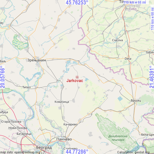
Jarkovac GPS coordinates[2]
45° 16' 11.46" North, 20° 45' 38.808" East
| Map corner | latitude | longitude |
|---|---|---|
| Upper-left | 45.76253°, | 20.05766° |
| Center: | 45.26985°, | 20.76078° |
| Lower-right: | 44.77286°, | 21.46391° |
| Map W x H: | 110×110 km | = 68.4×68.4mi |
| max Lat: | 46.1° ⇑25.9% North |
| Jarkovac: | 45.26985° |
| min Lat: | ⇓74.1% South 42.25846° |
| min Long | Jarkovac | max Long |
| 18.9276° | 20.76078° | 22.77556° |
| W 68.9%⇐ | ⇒31.1% E |
Elevation
Elevation of Jarkovac is 76 m = 249 ft, and this is 100.4 m = 329 ft below average elevation for this country.
| Max E: |
1421 m = 4662 ft | 90.7% |
| Avg. | 176.4 m = 579 ft | |
| Jarkovac | 76 m = 249 ft | |
Min E: |
49 m = 161 ft | 9.3% |
See also: Serbia elevation on elevation.city.
Geographical zone
Jarkovac is located in North temperate zone (between Tropic of Cancer and the Arctic Circle). Distance of this North polar circle is 2367.6 km =1471.2 mi to North.| Distance of | km | miles | from Jarkovac |
|---|---|---|---|
| North Pole | 4973.5 | 3090.4 | to North |
| Arctic Circle | 2367.6 | 1471.2 | to North |
| Tropic Cancer | 2427.6 | 1508.4 | to South |
| Equator | 5033.5 | 3127.7 | to South |


Nearby cities:
15 places around Jarkovac: (largest is in red/bold)
• Banatska Dubica
5.3 km =3.3 mi,  88°
88°
• Banatski Despotovac
13.1 km =8.1 mi,  324°
324°
• Boka
10.9 km =6.8 mi,  29°
29°
• Botoš
10.7 km =6.6 mi,  293°
293°
• Dobrica
9.4 km =5.8 mi,  131°
131°
• Hajdučica
15.8 km =9.8 mi,  98°
98°
• Konak
13.1 km =8.1 mi,  67°
67°
• Kozjak
12.6 km =7.8 mi,  140°
140°
• Neuzina
9.1 km =5.7 mi,  336°
336°
• Orlovat
14.4 km =8.9 mi,  257°
257°
• Samoš
7.6 km =4.7 mi,  172°
172°
• Sečanj
10.8 km =6.7 mi,  4°
4°
• Sutjeska
13.6 km =8.5 mi, 338°
• Tomaševac
10.8 km =6.7 mi,  269°
269°
• Uzdin
12.9 km =8 mi,  236°
236°
Sources, notices
• [Note1] Compared only with cities in Serbia existing in our database
• [Src1] Map data: © OpenStreetMap contributors (CC-BY-SA)
• [Src2] Other city data from geonames.org with taken over terms of usage.
• [Src3] Geographical zone / Annual Mean Temperature by Robert A. Rohde @ Wikipedia
