Fokino geodata
Fokino (Primorskiy (Maritime) Kray) is a populated place; located in Russia in Asia/Vladivostok (GMT+10) time zone. With population of 25,827 people, there are 736 cities with bigger population in this country. Compared to other cities in Russia, 97.7% of cities are located further ↑North; 95.6% of cities are located further ←West and 91.9% of cities have higher elevation than Fokino. Note1


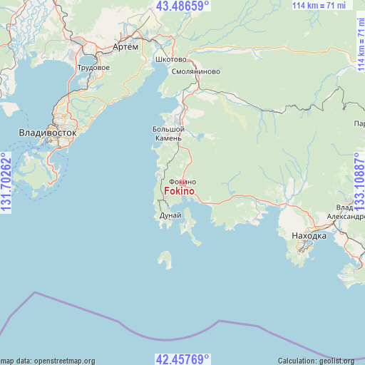
Fokino GPS coordinates[2]
42° 58' 27.444" North, 132° 24' 20.664" East
| Map corner | latitude | longitude |
|---|---|---|
| Upper-left | 43.48659°, | 131.70262° |
| Center: | 42.97429°, | 132.40574° |
| Lower-right: | 42.45769°, | 133.10887° |
| Map W x H: | 114.4×114.4 km | = 71.1×71.1mi |
| max Lat: | 73.50819° ⇑97.7% North |
| Fokino: | 42.97429° |
| min Lat: | ⇓2.3% South 41.28413° |
| min Long | Fokino | max Long |
| -179.12198° | 132.40574° | 179.35046° |
| W 95.6%⇐ | ⇒4.4% E |
Elevation
Elevation of Fokino is 22 m = 72 ft, and this is 180.6 m = 593 ft below average elevation for this country.
| Max E: |
2518 m = 8261 ft | 91.9% |
| Avg. | 202.6 m = 665 ft | |
| Fokino | 22 m = 72 ft | |
Min E: |
-28 m = -92 ft | 8.1% |
See also: Russia elevation on elevation.city.
Geographical zone
Fokino is located in North temperate zone (between Tropic of Cancer and the Arctic Circle). Distance of this Northern Tropic circle is 2172.4 km =1349.9 mi to South.| Distance of | km | miles | from Fokino |
|---|---|---|---|
| North Pole | 5228.8 | 3249 | to North |
| Arctic Circle | 2622.9 | 1629.8 | to North |
| Tropic Cancer | 2172.4 | 1349.9 | to South |
| Equator | 4778.3 | 2969.1 | to South |


Nearby cities:
15 places around Fokino: (largest is in red/bold)
• Artëm
46.3 km =28.8 mi,  337°
337°
• Bol’shoy Kamen’
16 km =9.9 mi, 344°
• Dunay
12.1 km =7.5 mi,  208°
208°
• Emar
32.6 km =20.3 mi,  321°
321°
• Livadiya
24.8 km =15.4 mi,  118°
118°
• Nakhodka
42.1 km =26.2 mi, 115°
• Putyatin
12.5 km =7.8 mi,  176°
176°
• Romanovka
29.1 km =18.1 mi,  8°
8°
• Russkiy
44.7 km =27.8 mi,  276°
276°
• Shkotovo
38.8 km =24.1 mi,  353°
353°
• Shtykovo
46.3 km =28.8 mi,  355°
355°
• Smolyaninovo
35.1 km =21.8 mi, 6°
• Trudovoye
45.2 km =28.1 mi, 322°
• Vladivostok
45.6 km =28.3 mi,  288°
288°
• Volchanets
29.8 km =18.5 mi,  103°
103°
Sources, notices
• [Note1] Compared only with cities in Russia existing in our database
• [Src1] Map data: © OpenStreetMap contributors (CC-BY-SA)
• [Src2] Other city data from geonames.org with taken over terms of usage.
• [Src3] Geographical zone / Annual Mean Temperature by Robert A. Rohde @ Wikipedia
