Livadiya geodata
Livadiya (Primorskiy (Maritime) Kray) is a populated place; located in Russia in Asia/Vladivostok (GMT+10) time zone. With population of 12,652 people, there are 1225 cities with bigger population in this country. Compared to other cities in Russia, 98% of cities are located further ↑North; 95.9% of cities are located further ←West and 94.5% of cities have higher elevation than Livadiya. Note1


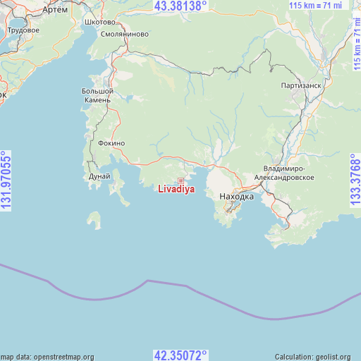
Livadiya GPS coordinates[2]
42° 52' 5.52" North, 132° 40' 25.212" East
| Map corner | latitude | longitude |
|---|---|---|
| Upper-left | 43.38138°, | 131.97055° |
| Center: | 42.8682°, | 132.67367° |
| Lower-right: | 42.35072°, | 133.3768° |
| Map W x H: | 114.6×114.6 km | = 71.2×71.2mi |
| max Lat: | 73.50819° ⇑98% North |
| Livadiya: | 42.8682° |
| min Lat: | ⇓2% South 41.28413° |
| min Long | Livadiya | max Long |
| -179.12198° | 132.67367° | 179.35046° |
| W 95.9%⇐ | ⇒4.1% E |
Elevation
Elevation of Livadiya is 14 m = 46 ft, and this is 188.6 m = 619 ft below average elevation for this country.
| Max E: |
2518 m = 8261 ft | 94.5% |
| Avg. | 202.6 m = 665 ft | |
| Livadiya | 14 m = 46 ft | |
Min E: |
-28 m = -92 ft | 5.5% |
See also: Russia elevation on elevation.city.
Geographical zone
Livadiya is located in North temperate zone (between Tropic of Cancer and the Arctic Circle). Distance of this Northern Tropic circle is 2160.6 km =1342.5 mi to South.| Distance of | km | miles | from Livadiya |
|---|---|---|---|
| North Pole | 5240.6 | 3256.4 | to North |
| Arctic Circle | 2634.7 | 1637.1 | to North |
| Tropic Cancer | 2160.6 | 1342.5 | to South |
| Equator | 4766.5 | 2961.8 | to South |


Nearby cities:
15 places around Livadiya: (largest is in red/bold)
• Bol’shoy Kamen’
37.6 km =23.4 mi,  316°
316°
• Dunay
27.6 km =17.1 mi,  272°
272°
• Emar
56.2 km =34.9 mi,  311°
311°
• Fokino
24.8 km =15.4 mi,  298°
298°
• Nakhodka
17.4 km =10.8 mi,  110°
110°
• Partizansk
46.2 km =28.7 mi,  52°
52°
• Putyatin
21 km =13 mi, 268°
• Romanovka
44.2 km =27.5 mi,  336°
336°
• Shkotovo
56.6 km =35.2 mi,  332°
332°
• Smolyaninovo
49.9 km =31 mi, 339°
• Uglekamensk
59.9 km =37.2 mi, 49°
• Vladimiro-Aleksandrovskoye
33 km =20.5 mi,  85°
85°
• Volchanets
8.8 km =5.5 mi, 54°
• Vrangel’
36.8 km =22.9 mi, 114°
• Yekaterinovka
31.2 km =19.4 mi,  78°
78°
Sources, notices
• [Note1] Compared only with cities in Russia existing in our database
• [Src1] Map data: © OpenStreetMap contributors (CC-BY-SA)
• [Src2] Other city data from geonames.org with taken over terms of usage.
• [Src3] Geographical zone / Annual Mean Temperature by Robert A. Rohde @ Wikipedia
