Russkiy geodata
Russkiy (Primorskiy (Maritime) Kray) is a populated place; located in Russia in Asia/Vladivostok (GMT+10) time zone. With population of 5,080 people, there are 2624 cities with bigger population in this country. Compared to other cities in Russia, 97.6% of cities are located further ↑North; 94.9% of cities are located further ←West and 84.6% of cities have higher elevation than Russkiy. Note1


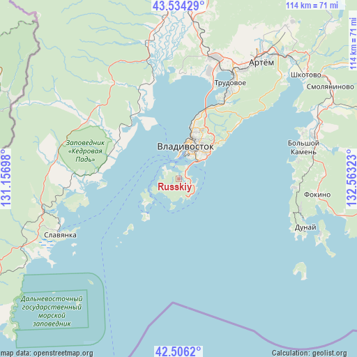
Russkiy GPS coordinates[2]
43° 1' 20.64" North, 131° 51' 36.36" East
| Map corner | latitude | longitude |
|---|---|---|
| Upper-left | 43.53429°, | 131.15698° |
| Center: | 43.0224°, | 131.8601° |
| Lower-right: | 42.5062°, | 132.56323° |
| Map W x H: | 114.3×114.3 km | = 71×71mi |
| max Lat: | 73.50819° ⇑97.6% North |
| Russkiy: | 43.0224° |
| min Lat: | ⇓2.4% South 41.28413° |
| min Long | Russkiy | max Long |
| -179.12198° | 131.8601° | 179.35046° |
| W 94.9%⇐ | ⇒5.1% E |
Elevation
Elevation of Russkiy is 49 m = 161 ft, and this is 153.6 m = 504 ft below average elevation for this country.
| Max E: |
2518 m = 8261 ft | 84.6% |
| Avg. | 202.6 m = 665 ft | |
| Russkiy | 49 m = 161 ft | |
Min E: |
-28 m = -92 ft | 15.4% |
See also: Russia elevation on elevation.city.
Geographical zone
Russkiy is located in North temperate zone (between Tropic of Cancer and the Arctic Circle). Distance of this Northern Tropic circle is 2177.7 km =1353.2 mi to South.| Distance of | km | miles | from Russkiy |
|---|---|---|---|
| North Pole | 5223.4 | 3245.7 | to North |
| Arctic Circle | 2617.5 | 1626.4 | to North |
| Tropic Cancer | 2177.7 | 1353.2 | to South |
| Equator | 4783.6 | 2972.4 | to South |


Nearby cities:
15 places around Russkiy: (largest is in red/bold)
• Barabash
35.8 km =22.2 mi,  303°
303°
• Bol’shoy Kamen’
41.4 km =25.7 mi,  75°
75°
• Devyatyy Val
31.7 km =19.7 mi,  356°
356°
• Dunay
41.8 km =26 mi,  112°
112°
• Emar
31.4 km =19.5 mi,  49°
49°
• Novyy
40.2 km =25 mi,  18°
18°
• Popova
12.9 km =8 mi,  238°
238°
• Primorskiy
23.6 km =14.7 mi,  291°
291°
• Slavyanka
42.2 km =26.2 mi,  245°
245°
• Tavrichanka
33.7 km =20.9 mi,  0°
0°
• Trudovoye
35 km =21.7 mi,  28°
28°
• Uglovoye
38.7 km =24 mi, 28°
• Vladivostok
9.3 km =5.8 mi,  6°
6°
• Vol’no-Nadezhdinskoye
40.7 km =25.3 mi, 15°
• Zanadvorovka
37.5 km =23.3 mi,  326°
326°
Sources, notices
• [Note1] Compared only with cities in Russia existing in our database
• [Src1] Map data: © OpenStreetMap contributors (CC-BY-SA)
• [Src2] Other city data from geonames.org with taken over terms of usage.
• [Src3] Geographical zone / Annual Mean Temperature by Robert A. Rohde @ Wikipedia
