Popova geodata
Popova (Primorskiy (Maritime) Kray) is a populated place; located in Russia in Asia/Vladivostok (GMT+10) time zone. With population of 1,285 people, there are 4486 cities with bigger population in this country. Compared to other cities in Russia, 97.8% of cities are located further ↑North; 94.8% of cities are located further ←West and 96.4% of cities have higher elevation than Popova. Note1


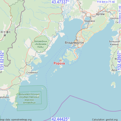
Popova GPS coordinates[2]
42° 57' 39.456" North, 131° 43' 29.784" East
| Map corner | latitude | longitude |
|---|---|---|
| Upper-left | 43.47337°, | 131.02182° |
| Center: | 42.96096°, | 131.72494° |
| Lower-right: | 42.44425°, | 132.42807° |
| Map W x H: | 114.4×114.4 km | = 71.1×71.1mi |
| max Lat: | 73.50819° ⇑97.8% North |
| Popova: | 42.96096° |
| min Lat: | ⇓2.2% South 41.28413° |
| min Long | Popova | max Long |
| -179.12198° | 131.72494° | 179.35046° |
| W 94.8%⇐ | ⇒5.2% E |
Elevation
Elevation of Popova is 9 m = 30 ft, and this is 193.6 m = 635 ft below average elevation for this country.
| Max E: |
2518 m = 8261 ft | 96.4% |
| Avg. | 202.6 m = 665 ft | |
| Popova | 9 m = 30 ft | |
Min E: |
-28 m = -92 ft | 3.6% |
See also: Russia elevation on elevation.city.
Geographical zone
Popova is located in North temperate zone (between Tropic of Cancer and the Arctic Circle). Distance of this Northern Tropic circle is 2170.9 km =1348.9 mi to South.| Distance of | km | miles | from Popova |
|---|---|---|---|
| North Pole | 5230.3 | 3250 | to North |
| Arctic Circle | 2624.4 | 1630.7 | to North |
| Tropic Cancer | 2170.9 | 1348.9 | to South |
| Equator | 4776.8 | 2968.2 | to South |


Nearby cities:
15 places around Popova: (largest is in red/bold)
• Barabash
32.6 km =20.3 mi,  324°
324°
• Bol’shoy Kamen’
53.8 km =33.4 mi,  71°
71°
• Devyatyy Val
39.5 km =24.5 mi,  13°
13°
• Dunay
50.5 km =31.4 mi,  100°
100°
• Emar
44.3 km =27.5 mi,  52°
52°
• Novyy
50.9 km =31.6 mi,  28°
28°
• Primorskiy
18.9 km =11.7 mi, 324°
• Russkiy
12.9 km =8 mi,  58°
58°
• Slavyanka
29.5 km =18.3 mi,  248°
248°
• Tavrichanka
42 km =26.1 mi,  15°
15°
• Trudovoye
46.7 km =29 mi,  36°
36°
• Uglovoye
50.4 km =31.3 mi, 35°
• Vladivostok
20.1 km =12.5 mi, 36°
• Vol’no-Nadezhdinskoye
51 km =31.7 mi, 25°
• Zanadvorovka
39.2 km =24.4 mi,  345°
345°
Sources, notices
• [Note1] Compared only with cities in Russia existing in our database
• [Src1] Map data: © OpenStreetMap contributors (CC-BY-SA)
• [Src2] Other city data from geonames.org with taken over terms of usage.
• [Src3] Geographical zone / Annual Mean Temperature by Robert A. Rohde @ Wikipedia
