Vanino geodata
Vanino (Khabarovsk) is a populated place; located in Russia in Asia/Vladivostok (GMT+10) time zone. With population of 18,618 people, there are 923 cities with bigger population in this country. Compared to other cities in Russia, 78.9% of cities are located further ↑North; 97.8% of cities are located further ←West and 77.2% of cities have higher elevation than Vanino. Note1


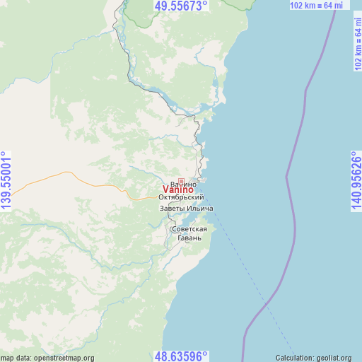
Vanino GPS coordinates[2]
49° 5' 54.528" North, 140° 15' 11.268" East
| Map corner | latitude | longitude |
|---|---|---|
| Upper-left | 49.55673°, | 139.55001° |
| Center: | 49.09848°, | 140.25313° |
| Lower-right: | 48.63596°, | 140.95626° |
| Map W x H: | 102.4×102.4 km | = 63.6×63.6mi |
| max Lat: | 73.50819° ⇑78.9% North |
| Vanino: | 49.09848° |
| min Lat: | ⇓21.1% South 41.28413° |
| min Long | Vanino | max Long |
| -179.12198° | 140.25313° | 179.35046° |
| W 97.8%⇐ | ⇒2.2% E |
Elevation
Elevation of Vanino is 80 m = 262 ft, and this is 122.6 m = 402 ft below average elevation for this country.
| Max E: |
2518 m = 8261 ft | 77.2% |
| Avg. | 202.6 m = 665 ft | |
| Vanino | 80 m = 262 ft | |
Min E: |
-28 m = -92 ft | 22.8% |
See also: Russia elevation on elevation.city.
Geographical zone
Vanino is located in North temperate zone (between Tropic of Cancer and the Arctic Circle). Distance of this North polar circle is 1941.9 km =1206.6 mi to North.| Distance of | km | miles | from Vanino |
|---|---|---|---|
| North Pole | 4547.8 | 2825.9 | to North |
| Arctic Circle | 1941.9 | 1206.6 | to North |
| Tropic Cancer | 2853.3 | 1773 | to South |
| Equator | 5459.2 | 3392.2 | to South |


Nearby cities:
15 places around Vanino: (largest is in red/bold)
• Boshnyakovo
151.6 km =94.2 mi,  66°
66°
• Gatka
24.2 km =15 mi,  201°
201°
• Krasnogorsk
154.3 km =95.9 mi,  119°
119°
• Leonidovo
191.3 km =118.9 mi,  83°
83°
• Lososina
12.2 km =7.6 mi,  158°
158°
• Makarov
192.1 km =119.4 mi,  105°
105°
• Mayskiy
11.5 km =7.1 mi, 195°
• Shakhtersk
137.2 km =85.3 mi,  86°
86°
• Sovetskaya Gavan’
14.3 km =8.9 mi,  169°
169°
• Tikhmenevo
192.3 km =119.5 mi, 86°
• Udarnyy
137.3 km =85.3 mi, 89°
• Uglegorsk
131.9 km =82 mi, 90°
• Vostok
194.5 km =120.9 mi, 93°
• Vysokogornyy
137.9 km =85.7 mi,  323°
323°
• Zavety Il’icha
6.9 km =4.3 mi, 169°
Sources, notices
• [Note1] Compared only with cities in Russia existing in our database
• [Src1] Map data: © OpenStreetMap contributors (CC-BY-SA)
• [Src2] Other city data from geonames.org with taken over terms of usage.
• [Src3] Geographical zone / Annual Mean Temperature by Robert A. Rohde @ Wikipedia
