Slavniy geodata
Slavniy (Tula) is a populated place; located in Russia in Europe/Moscow (GMT+3) time zone. With population of 1,870 people, there are 4230 cities with bigger population in this country. Compared to other cities in Russia, 58.4% of cities are located further ↑North; 86.3% of cities are located further →East and 75.7% of cities have lower elevation than Slavniy. Note1


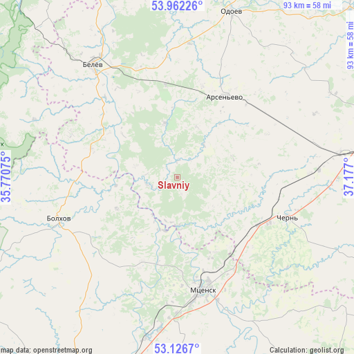
Slavniy GPS coordinates[2]
53° 32' 47.544" North, 36° 28' 25.932" East
| Map corner | latitude | longitude |
|---|---|---|
| Upper-left | 53.96226°, | 35.77075° |
| Center: | 53.54654°, | 36.47387° |
| Lower-right: | 53.1267°, | 37.177° |
| Map W x H: | 92.9×92.9 km | = 57.7×57.7mi |
| max Lat: | 73.50819° ⇑58.4% North |
| Slavniy: | 53.54654° |
| min Lat: | ⇓41.6% South 41.28413° |
| min Long | Slavniy | max Long |
| -179.12198° | 36.47387° | 179.35046° |
| W 13.7%⇐ | ⇒86.3% E |
Elevation
Elevation of Slavniy is 220 m = 722 ft, and this is 17.4 m = 57 ft above average elevation for this country.
| Max E: |
2518 m = 8261 ft | 24.3% |
| Slavniy | 220 m 722 ft | |
| Avg. | 202.6 m = 665 ft | |
Min E: |
-28 m = -92 ft | 75.7% |
See also: Russia elevation on elevation.city.
Geographical zone
Slavniy is located in North temperate zone (between Tropic of Cancer and the Arctic Circle). Distance of this North polar circle is 1447.4 km =899.4 mi to North.| Distance of | km | miles | from Slavniy |
|---|---|---|---|
| North Pole | 4053.2 | 2518.5 | to North |
| Arctic Circle | 1447.4 | 899.4 | to North |
| Tropic Cancer | 3347.9 | 2080.3 | to South |
| Equator | 5953.8 | 3699.5 | to South |


Nearby cities:
15 places around Slavniy: (largest is in red/bold)
• Arsen’yevo
24.8 km =15.4 mi,  30°
30°
• Belëv
37.1 km =23.1 mi,  322°
322°
• Bolkhov
33.1 km =20.6 mi,  249°
249°
• Bol’shoye Skuratovo
27.1 km =16.8 mi,  116°
116°
• Chekalin
63 km =39.1 mi,  346°
346°
• Cherepet’
63.8 km =39.6 mi, 354°
• Chern’
31 km =19.3 mi,  109°
109°
• Krapivna
62.9 km =39.1 mi,  45°
45°
• Mtsensk
30.7 km =19.1 mi,  167°
167°
• Odoyev
45.9 km =28.5 mi,  17°
17°
• Plavsk
56.9 km =35.4 mi,  71°
71°
• Spasskoye-Lutovinovo
22 km =13.7 mi,  153°
153°
• Suvorov
64 km =39.8 mi,  1°
1°
• Zarech’ye
59.1 km =36.7 mi,  290°
290°
• Znamenskoye
59.8 km =37.2 mi,  240°
240°
Sources, notices
• [Note1] Compared only with cities in Russia existing in our database
• [Src1] Map data: © OpenStreetMap contributors (CC-BY-SA)
• [Src2] Other city data from geonames.org with taken over terms of usage.
• [Src3] Geographical zone / Annual Mean Temperature by Robert A. Rohde @ Wikipedia
