Spasskoye-Lutovinovo geodata
Spasskoye-Lutovinovo (Orel Oblast) is a populated place; located in Russia in Europe/Moscow (GMT+3) time zone. With population of 1,411 people, there are 4424 cities with bigger population in this country. Compared to other cities in Russia, 59.8% of cities are located further ↑North; 85.9% of cities are located further →East and 78.4% of cities have lower elevation than Spasskoye-Lutovinovo. Note1


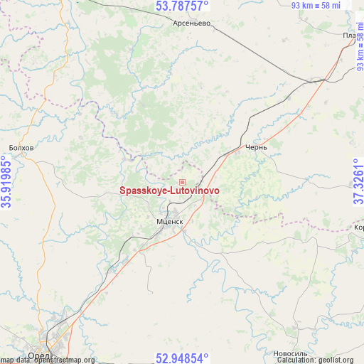
Spasskoye-Lutovinovo GPS coordinates[2]
53° 22' 12.432" North, 36° 37' 22.692" East
| Map corner | latitude | longitude |
|---|---|---|
| Upper-left | 53.78757°, | 35.91985° |
| Center: | 53.37012°, | 36.62297° |
| Lower-right: | 52.94854°, | 37.3261° |
| Map W x H: | 93.3×93.3 km | = 58×58mi |
| max Lat: | 73.50819° ⇑59.8% North |
| Spasskoye-Lutovinovo: | 53.37012° |
| min Lat: | ⇓40.2% South 41.28413° |
| min Long | Spasskoye-Lutov | max Long |
| -179.12198° | 36.62297° | 179.35046° |
| W 14.1%⇐ | ⇒85.9% E |
Elevation
Elevation of Spasskoye-Lutovinovo is 237 m = 778 ft, and this is 34.4 m = 113 ft above average elevation for this country.
| Max E: |
2518 m = 8261 ft | 21.6% |
| Spasskoye-Lutovinovo | 237 m 778 ft | |
| Avg. | 202.6 m = 665 ft | |
Min E: |
-28 m = -92 ft | 78.4% |
See also: Russia elevation on elevation.city.
Geographical zone
Spasskoye-Lutovinovo is located in North temperate zone (between Tropic of Cancer and the Arctic Circle). Distance of this North polar circle is 1467 km =911.6 mi to North.| Distance of | km | miles | from Spasskoye-Lutovinovo |
|---|---|---|---|
| North Pole | 4072.9 | 2530.8 | to North |
| Arctic Circle | 1467 | 911.6 | to North |
| Tropic Cancer | 3328.3 | 2068.1 | to South |
| Equator | 5934.2 | 3687.3 | to South |


Nearby cities:
15 places around Spasskoye-Lutovinovo: (largest is in red/bold)
• Arsen’yevo
41.1 km =25.5 mi,  3°
3°
• Belëv
58.9 km =36.6 mi,  326°
326°
• Bolkhov
41.7 km =25.9 mi,  281°
281°
• Bol’shoye Skuratovo
16.3 km =10.1 mi,  62°
62°
• Chern’
21.4 km =13.3 mi, 64°
• Korsakovo
50.1 km =31.1 mi,  103°
103°
• Mtsensk
10.9 km =6.8 mi,  197°
197°
• Novosil’
52.1 km =32.4 mi,  147°
147°
• Odoyev
63.4 km =39.4 mi, 3°
• Orël
57.8 km =35.9 mi,  218°
218°
• Plavsk
58.1 km =36.1 mi,  49°
49°
• Slavniy
22 km =13.7 mi, 333°
• Zalegoshch’
55.4 km =34.4 mi,  161°
161°
• Znamenka
67.9 km =42.2 mi, 219°
• Znamenskoye
62.8 km =39 mi,  260°
260°
Sources, notices
• [Note1] Compared only with cities in Russia existing in our database
• [Src1] Map data: © OpenStreetMap contributors (CC-BY-SA)
• [Src2] Other city data from geonames.org with taken over terms of usage.
• [Src3] Geographical zone / Annual Mean Temperature by Robert A. Rohde @ Wikipedia
