Plavsk geodata
Plavsk (Tula) is a populated place; located in Russia in Europe/Moscow (GMT+3) time zone. With population of 16,763 people, there are 1010 cities with bigger population in this country. Compared to other cities in Russia, 57.4% of cities are located further ↑North; 83.5% of cities are located further →East and 64.3% of cities have lower elevation than Plavsk. Note1


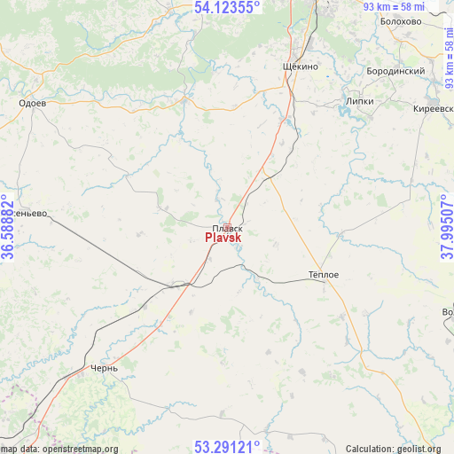
Plavsk GPS coordinates[2]
53° 42' 33.984" North, 37° 17' 30.984" East
| Map corner | latitude | longitude |
|---|---|---|
| Upper-left | 54.12355°, | 36.58882° |
| Center: | 53.70944°, | 37.29194° |
| Lower-right: | 53.29121°, | 37.99507° |
| Map W x H: | 92.5×92.5 km | = 57.5×57.5mi |
| max Lat: | 73.50819° ⇑57.4% North |
| Plavsk: | 53.70944° |
| min Lat: | ⇓42.6% South 41.28413° |
| min Long | Plavsk | max Long |
| -179.12198° | 37.29194° | 179.35046° |
| W 16.5%⇐ | ⇒83.5% E |
Elevation
Elevation of Plavsk is 180 m = 591 ft, and this is 22.6 m = 74 ft below average elevation for this country.
| Max E: |
2518 m = 8261 ft | 35.7% |
| Avg. | 202.6 m = 665 ft | |
| Plavsk | 180 m = 591 ft | |
Min E: |
-28 m = -92 ft | 64.3% |
See also: Russia elevation on elevation.city.
Geographical zone
Plavsk is located in North temperate zone (between Tropic of Cancer and the Arctic Circle). Distance of this North polar circle is 1429.2 km =888.1 mi to North.| Distance of | km | miles | from Plavsk |
|---|---|---|---|
| North Pole | 4035.1 | 2507.3 | to North |
| Arctic Circle | 1429.2 | 888.1 | to North |
| Tropic Cancer | 3366 | 2091.5 | to South |
| Equator | 5971.9 | 3710.8 | to South |


Nearby cities:
15 places around Plavsk: (largest is in red/bold)
• Arsen’yevo
41.4 km =25.7 mi,  274°
274°
• Bol’shoye Skuratovo
42.4 km =26.3 mi,  224°
224°
• Borodinskiy
47.2 km =29.3 mi,  47°
47°
• Chern’
37.9 km =23.5 mi, 221°
• Kireyevsk
48.6 km =30.2 mi,  59°
59°
• Kosaya Gora
48.4 km =30.1 mi,  19°
19°
• Krapivna
27.4 km =17 mi,  341°
341°
• Lomintsevskiy
39.2 km =24.4 mi,  38°
38°
• Odoyev
47.3 km =29.4 mi,  302°
302°
• Pervomayskiy
39.9 km =24.8 mi, 20°
• Priupskiy
36.7 km =22.8 mi, 52°
• Shchëkino
36.2 km =22.5 mi, 24°
• Skuratovskiy
48.1 km =29.9 mi,  25°
25°
• Tëploye
22 km =13.7 mi,  116°
116°
• Yasnaya Polyana
42.7 km =26.5 mi, 20°
Sources, notices
• [Note1] Compared only with cities in Russia existing in our database
• [Src1] Map data: © OpenStreetMap contributors (CC-BY-SA)
• [Src2] Other city data from geonames.org with taken over terms of usage.
• [Src3] Geographical zone / Annual Mean Temperature by Robert A. Rohde @ Wikipedia
