Zvenigorod geodata
Zvenigorod (Moscow Oblast) is a populated place; located in Russia in Europe/Moscow (GMT+3) time zone. With population of 16,395 people, there are 1022 cities with bigger population in this country. Compared to other cities in Russia, 62.5% of cities are located further ↓South; 85.3% of cities are located further →East and 63.6% of cities have lower elevation than Zvenigorod. Note1


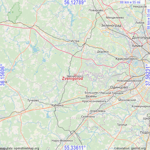
Zvenigorod GPS coordinates[2]
55° 44' 2.436" North, 36° 51' 33.048" East
| Map corner | latitude | longitude |
|---|---|---|
| Upper-left | 56.12789°, | 36.15606° |
| Center: | 55.73401°, | 36.85918° |
| Lower-right: | 55.33611°, | 37.56231° |
| Map W x H: | 88×88 km | = 54.7×54.7mi |
| max Lat: | 73.50819° ⇑37.5% North |
| Zvenigorod: | 55.73401° |
| min Lat: | ⇓62.5% South 41.28413° |
| min Long | Zvenigorod | max Long |
| -179.12198° | 36.85918° | 179.35046° |
| W 14.7%⇐ | ⇒85.3% E |
Elevation
Elevation of Zvenigorod is 178 m = 584 ft, and this is 24.6 m = 81 ft below average elevation for this country.
| Max E: |
2518 m = 8261 ft | 36.4% |
| Avg. | 202.6 m = 665 ft | |
| Zvenigorod | 178 m = 584 ft | |
Min E: |
-28 m = -92 ft | 63.6% |
See also: Russia elevation on elevation.city.
Geographical zone
Zvenigorod is located in North temperate zone (between Tropic of Cancer and the Arctic Circle). Distance of this North polar circle is 1204.1 km =748.2 mi to North.| Distance of | km | miles | from Zvenigorod |
|---|---|---|---|
| North Pole | 3810 | 2367.4 | to North |
| Arctic Circle | 1204.1 | 748.2 | to North |
| Tropic Cancer | 3591.1 | 2231.4 | to South |
| Equator | 6197 | 3850.6 | to South |


Nearby cities:
15 places around Zvenigorod: (largest is in red/bold)
• Bol'shiye Vyazëmy
14.6 km =9.1 mi,  149°
149°
• Dmitrovskoye
16.6 km =10.3 mi,  81°
81°
• Golitsyno
15.9 km =9.9 mi, 150°
• Gorki Vtoryye
19.1 km =11.9 mi,  92°
92°
• Karinskoye
11 km =6.8 mi,  255°
255°
• Krasnoznamensk
18.7 km =11.6 mi,  143°
143°
• Kubinka
19.7 km =12.2 mi,  209°
209°
• Nazar'yevo
13.2 km =8.2 mi,  120°
120°
• Nikolina Gora
11.5 km =7.1 mi, 89°
• Pavlovskaya Sloboda
16.6 km =10.3 mi,  57°
57°
• Petrovo-Dal’neye
19.7 km =12.2 mi, 85°
• Rozhdestveno
17.9 km =11.1 mi,  41°
41°
• Savvinskaya Sloboda
3.7 km =2.3 mi,  251°
251°
• Yershovo
3.9 km =2.4 mi,  0°
0°
• Zhavoronki
17.8 km =11.1 mi, 121°
Sources, notices
• [Note1] Compared only with cities in Russia existing in our database
• [Src1] Map data: © OpenStreetMap contributors (CC-BY-SA)
• [Src2] Other city data from geonames.org with taken over terms of usage.
• [Src3] Geographical zone / Annual Mean Temperature by Robert A. Rohde @ Wikipedia
