Zimogor’ye geodata
Zimogor’ye (Novgorod Oblast) is a populated place; located in Russia in Europe/Moscow (GMT+3) time zone. With population of 804 people, there are 4751 cities with bigger population in this country. Compared to other cities in Russia, 82.4% of cities are located further ↓South; 91.7% of cities are located further →East and 78% of cities have lower elevation than Zimogor’ye. Note1


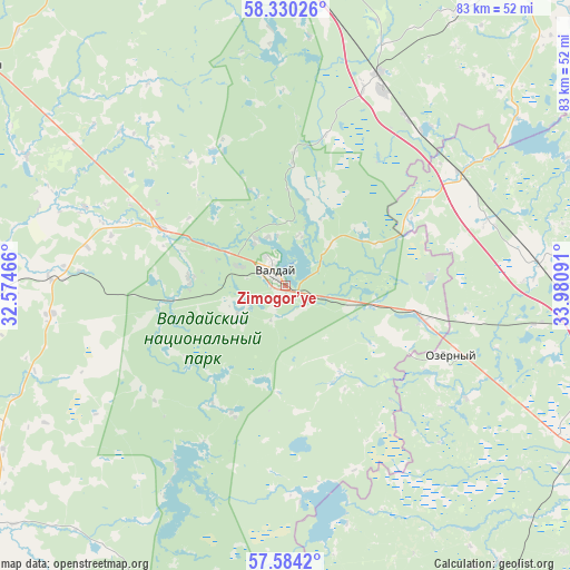
Zimogor’ye GPS coordinates[2]
57° 57' 33.012" North, 33° 16' 40.008" East
| Map corner | latitude | longitude |
|---|---|---|
| Upper-left | 58.33026°, | 32.57466° |
| Center: | 57.95917°, | 33.27778° |
| Lower-right: | 57.5842°, | 33.98091° |
| Map W x H: | 83×83 km | = 51.6×51.6mi |
| max Lat: | 73.50819° ⇑17.6% North |
| Zimogor’ye: | 57.95917° |
| min Lat: | ⇓82.4% South 41.28413° |
| min Long | Zimogor’ye | max Long |
| -179.12198° | 33.27778° | 179.35046° |
| W 8.3%⇐ | ⇒91.7% E |
Elevation
Elevation of Zimogor’ye is 233 m = 764 ft, and this is 30.4 m = 100 ft above average elevation for this country.
| Max E: |
2518 m = 8261 ft | 22% |
| Zimogor’ye | 233 m 764 ft | |
| Avg. | 202.6 m = 665 ft | |
Min E: |
-28 m = -92 ft | 78% |
See also: Russia elevation on elevation.city.
Geographical zone
Zimogor’ye is located in North temperate zone (between Tropic of Cancer and the Arctic Circle). Distance of this North polar circle is 956.7 km =594.5 mi to North.| Distance of | km | miles | from Zimogor’ye |
|---|---|---|---|
| North Pole | 3562.6 | 2213.7 | to North |
| Arctic Circle | 956.7 | 594.5 | to North |
| Tropic Cancer | 3838.5 | 2385.1 | to South |
| Equator | 6444.5 | 4004.4 | to South |


Nearby cities:
15 places around Zimogor’ye: (largest is in red/bold)
• Berezayka
37 km =23 mi,  84°
84°
• Bologoye
46.2 km =28.7 mi,  100°
100°
• Bologoye-4
22.9 km =14.2 mi,  106°
106°
• Demyansk
59.6 km =37 mi,  233°
233°
• Firovo
58.8 km =36.5 mi,  154°
154°
• Kresttsy
54.9 km =34.1 mi,  305°
305°
• Kulotino
54.9 km =34.1 mi,  6°
6°
• Kuzhenkino
45.5 km =28.3 mi,  118°
118°
• Lykoshino
30.3 km =18.8 mi,  57°
57°
• Okulovka
49.1 km =30.5 mi,  0°
0°
• Trud
56.3 km =35 mi,  133°
133°
• Uglovka
34 km =21.1 mi,  23°
23°
• Valday
2.8 km =1.7 mi,  319°
319°
• Vypolzovo
26.5 km =16.5 mi, 110°
• Yedrovo
20.9 km =13 mi, 104°
Sources, notices
• [Note1] Compared only with cities in Russia existing in our database
• [Src1] Map data: © OpenStreetMap contributors (CC-BY-SA)
• [Src2] Other city data from geonames.org with taken over terms of usage.
• [Src3] Geographical zone / Annual Mean Temperature by Robert A. Rohde @ Wikipedia
