Kuzhenkino geodata
Kuzhenkino (Tver’ Oblast) is a populated place; located in Russia in Europe/Moscow (GMT+3) time zone. With population of 3,424 people, there are 3455 cities with bigger population in this country. Compared to other cities in Russia, 81.3% of cities are located further ↓South; 90.6% of cities are located further →East and 69% of cities have lower elevation than Kuzhenkino. Note1


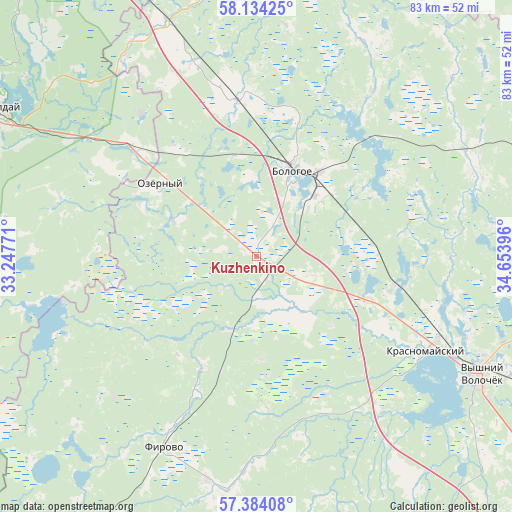
Kuzhenkino GPS coordinates[2]
57° 45' 39.996" North, 33° 57' 2.988" East
| Map corner | latitude | longitude |
|---|---|---|
| Upper-left | 58.13425°, | 33.24771° |
| Center: | 57.76111°, | 33.95083° |
| Lower-right: | 57.38408°, | 34.65396° |
| Map W x H: | 83.4×83.4 km | = 51.8×51.8mi |
| max Lat: | 73.50819° ⇑18.7% North |
| Kuzhenkino: | 57.76111° |
| min Lat: | ⇓81.3% South 41.28413° |
| min Long | Kuzhenkino | max Long |
| -179.12198° | 33.95083° | 179.35046° |
| W 9.4%⇐ | ⇒90.6% E |
Elevation
Elevation of Kuzhenkino is 194 m = 636 ft, and this is 8.6 m = 28 ft below average elevation for this country.
| Max E: |
2518 m = 8261 ft | 31% |
| Avg. | 202.6 m = 665 ft | |
| Kuzhenkino | 194 m = 636 ft | |
Min E: |
-28 m = -92 ft | 69% |
See also: Russia elevation on elevation.city.
Geographical zone
Kuzhenkino is located in North temperate zone (between Tropic of Cancer and the Arctic Circle). Distance of this North polar circle is 978.7 km =608.1 mi to North.| Distance of | km | miles | from Kuzhenkino |
|---|---|---|---|
| North Pole | 3584.6 | 2227.4 | to North |
| Arctic Circle | 978.7 | 608.1 | to North |
| Tropic Cancer | 3816.5 | 2371.5 | to South |
| Equator | 6422.4 | 3990.7 | to South |


Nearby cities:
15 places around Kuzhenkino: (largest is in red/bold)
• Berezayka
25.4 km =15.8 mi,  353°
353°
• Bologoye
15 km =9.3 mi,  22°
22°
• Bologoye-4
23.6 km =14.7 mi,  310°
310°
• Firovo
34.5 km =21.4 mi,  205°
205°
• Krasnomayskiy
31.5 km =19.6 mi,  120°
120°
• Lykoshino
40.7 km =25.3 mi,  339°
339°
• Opechenskiy Posad
58 km =36 mi,  9°
9°
• Trud
16.8 km =10.4 mi,  177°
177°
• Uglovka
59.1 km =36.7 mi,  334°
334°
• Valday
48.1 km =29.9 mi,  300°
300°
• Velikooktyabr’skiy
37.3 km =23.2 mi,  192°
192°
• Vypolzovo
19.7 km =12.2 mi, 310°
• Vyshniy Volochëk
41.1 km =25.5 mi, 117°
• Yedrovo
25.9 km =16.1 mi, 310°
• Zimogor’ye
45.5 km =28.3 mi, 298°
Sources, notices
• [Note1] Compared only with cities in Russia existing in our database
• [Src1] Map data: © OpenStreetMap contributors (CC-BY-SA)
• [Src2] Other city data from geonames.org with taken over terms of usage.
• [Src3] Geographical zone / Annual Mean Temperature by Robert A. Rohde @ Wikipedia
