Zaplavnoye geodata
Zaplavnoye (Volgograd Oblast) is a populated place; located in Russia in Europe/Volgograd (GMT+3) time zone. With population of 3,693 people, there are 3277 cities with bigger population in this country. Compared to other cities in Russia, 79.5% of cities are located further ↑North; 50.1% of cities are located further ←West and 99.2% of cities have higher elevation than Zaplavnoye. Note1


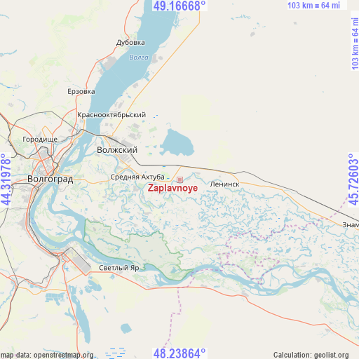
Zaplavnoye GPS coordinates[2]
48° 42' 17.28" North, 45° 1' 22.44" East
| Map corner | latitude | longitude |
|---|---|---|
| Upper-left | 49.16668°, | 44.31978° |
| Center: | 48.7048°, | 45.0229° |
| Lower-right: | 48.23864°, | 45.72603° |
| Map W x H: | 103.2×103.2 km | = 64.1×64.1mi |
| max Lat: | 73.50819° ⇑79.5% North |
| Zaplavnoye: | 48.7048° |
| min Lat: | ⇓20.5% South 41.28413° |
| min Long | Zaplavnoye | max Long |
| -179.12198° | 45.0229° | 179.35046° |
| W 50.1%⇐ | ⇒49.9% E |
Elevation
Elevation of Zaplavnoye is -7 m = -23 ft, and this is 209.6 m = 688 ft below average elevation for this country.
| Max E: |
2518 m = 8261 ft | 99.2% |
| Avg. | 202.6 m = 665 ft | |
| Zaplavnoye | -7 m = -23 ft | |
Min E: |
-28 m = -92 ft | 0.8% |
See also: Russia elevation on elevation.city.
Geographical zone
Zaplavnoye is located in North temperate zone (between Tropic of Cancer and the Arctic Circle). Distance of this North polar circle is 1985.7 km =1233.9 mi to North.| Distance of | km | miles | from Zaplavnoye |
|---|---|---|---|
| North Pole | 4591.6 | 2853.1 | to North |
| Arctic Circle | 1985.7 | 1233.9 | to North |
| Tropic Cancer | 2809.5 | 1745.7 | to South |
| Equator | 5415.5 | 3365 | to South |


Nearby cities:
15 places around Zaplavnoye: (largest is in red/bold)
• Bereslavka
72.4 km =45 mi,  262°
262°
• Dubovka
41.8 km =26 mi,  340°
340°
• Gorodishche
41.7 km =25.9 mi,  285°
285°
• Gumrak
47.8 km =29.7 mi,  280°
280°
• Kapustin Yar
54.8 km =34.1 mi,  104°
104°
• Krasnoslobodsk
32.7 km =20.3 mi,  270°
270°
• Leninsk
12.9 km =8 mi,  91°
91°
• Novyy Rogachik
70.7 km =43.9 mi, 267°
• Primorsk
62.3 km =38.7 mi,  0°
0°
• Srednyaya Akhtuba
11.4 km =7.1 mi, 272°
• Svetlyy Yar
31.2 km =19.4 mi,  214°
214°
• Vodstroy
37.3 km =23.2 mi, 294°
• Volgograd
38.3 km =23.8 mi, 272°
• Volzhskiy
20 km =12.4 mi,  296°
296°
• Znamensk
53.9 km =33.5 mi, 104°
Sources, notices
• [Note1] Compared only with cities in Russia existing in our database
• [Src1] Map data: © OpenStreetMap contributors (CC-BY-SA)
• [Src2] Other city data from geonames.org with taken over terms of usage.
• [Src3] Geographical zone / Annual Mean Temperature by Robert A. Rohde @ Wikipedia
